| ©The Archaeological Settlements of Turkey - TAY Project | ||||||
|
|
||||||
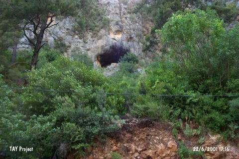
Gavurini Magarasi |
||||||
|
|
||||||
| Ages | Maps | Photos | ||||
| Palaeolithic/Epipalaeolithic EBA |
 |
 |
||||
|
|
||||||
|
Type:
|
Cave | |||||
|
Altitude:
|
1140 m | |||||
|
Diameter:
|
m- Direction: | |||||
|
|
||||||
|
Region:
|
Mediterranean | |||||
|
Province:
|
Antalya | |||||
|
District:
|
Alanya | |||||
|
Village:
|
Obaköy | |||||
|
|
||||||
|
Destruction :
|
Illicit Digging - Attention | |||||
|
|
||||||
|
TAYEx:
|
Visited - 22/6/2001 | |||||
|
|
||||||
|
Registration State:
|
For detailed registration information please refer to Turkish pages. | |||||
 |
||||||
| Location: This cave-site is in Obaköy Village; which is 3.8 km from the town center of Alanya; southeast of the city of Antalya. The cave is located in a deep valley on the Gömerme Hill in Kadipinari Mevkii. This valley is to the northeast of Oba stream and Yayla-Degirmendere road. It is also known as Kadipinari/Kadiini cave due to its location but the local name is Gavurini. |
| Geography and Environment: The cave; which has a ceiling height of 10-20 m; is pretty large and deep. The big rocks in the entrance do not block the entry. It is 50 m high from the road. |
| Destruction Details: There are pits of illicit diggings at the entrance of the cave [TAYEx 22.6.2001]. |