| ©The Archaeological Settlements of Turkey - TAY Project | ||||||
|
|
||||||
Gökhöyük |
||||||
|
|
||||||
| Ages | Maps | Photos | ||||
| Neolithic EBA |
 |
 |
||||
|
|
||||||
|
Type:
|
Mound | |||||
|
Altitude:
|
290 m | |||||
|
Diameter:
|
m- Direction: | |||||
|
|
||||||
|
Region:
|
Mediterranean | |||||
|
Province:
|
Antalya | |||||
|
District:
|
Merkez | |||||
|
Village:
|
Yeniköy | |||||
|
|
||||||
|
Destruction :
|
Illicit Digging - Agriculture - Attention | |||||
|
|
||||||
|
TAYEx:
|
Visited - 20/6/2001 | |||||
|
|
||||||
|
Registration State:
|
Registered For detailed registration information please refer to Turkish pages. | |||||
 |
||||||
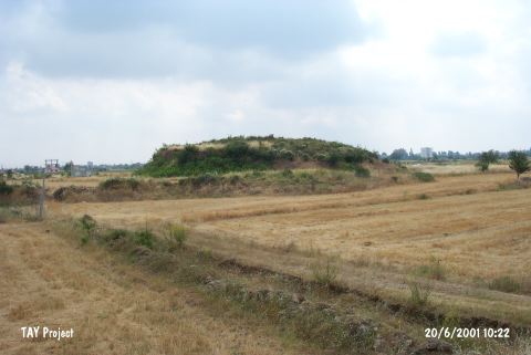
| Location: This site lies northwest of the city of Antalya; 1 km northwest of the town of Yeniköy; west of the old Antalya-Burdur highway and 2.5 km southwest of the village of Yalnizköy. |
| Geography and Environment: This mound site lies in the travertine plain at the foot of Mount Katran. It has been reported that the height of the mound is between 5-6 m. The site was partially destroyed as a result of canal construction in 1984. |
| Destruction Details: The mound has been damaged due to agricultural activities and illicit diggings. Soil removed from its skirts and southern slope excavated towards top hill. There is an other pit in half a meter depth on top [TAYEx 20.6.2001]. |