|
©The Archaeological Settlements of Turkey - TAY Project
|
|
|
|
|
Anastasius Surlari |
|
|
|
|
|
For site maps and drawings please click on the picture... 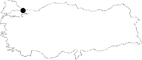 |
For photographs please click on the photo... 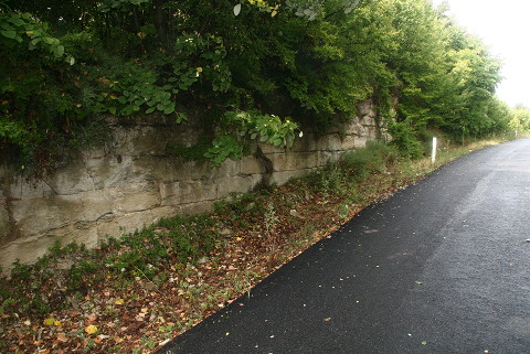 |
|
|
|
|
Type:
|
City Wall |
|
Plan Type:
|
|
|
Year of Costruction:
|
502 - 506 |
|
Phase:
|
Early |
|
Investigation Method:
|
Survey |
|
Altitude:
|
90 |
|
|
|
|
Region:
|
Marmara |
|
Province:
|
Istanbul |
|
District:
|
Silivri |
|
Village:
|
|
|
Antique Name:
|
|
|
|
|
 |
|
| Location: The Anastasian Wall is located 65 km west of Istanbul. It stretches from the Evcik Iskelesi at Black Sea shore to the Marmara Sea at the west of Silivri [Crow-Ricci 1997:235]. |
| Geography and Environment: Referred as "the Anastasian Wall" or "the Long Wall" in ancient sources, this line of defence was built against the Bulgarian attacks, which were a major threat for the city at the time. The beginning of the fortification in the north direction is the point where the church resides on the slope in Evcik. The termination point is to the west of Silivri. |
| Research and Excavation: Surveys were conducted by C. Schuchhardt in 1898, by F. Dirimtekin at late 1940s, and by R.M. Harrison at late 1960s. Lastly, J. Crow and A. Ricci conducted a detailed survey as part of their project initiated in 1994 and ended in 1997 [Crow-Ricci 1997:235-262; Crow-Ricci 1998:239-249]. |
| Description: Building Phases: The wall was built in the early 6th century around 502-506 (Croke 1982, 73-74) by the Emperor Anastasius (491-518). As a result of damages sustained from the Barbarian incursions and the earthquakes in 557, the wall underwent restoration two times during the reign of Justinianus [Crow-Ricci 1997:239-240]. According to the Byzantine sources, such renovations didn't contribute much to the defense system of the city although they were repaired by the emperors. The renovation activities continued up to the 10th or 11th century [Dirimtekin 1948:9; Harrison 1970:78]. Architectural Features: The southern end of the wall starts from the Cape Karinca, west of Silivri. It stretches northward along the Kale Yolu on a low ridge, which can be traced easily until Kurfali where the wall becomes full of hillocks and debris pits. Thereafter, it can be, although shortly, traceable along the railway line. Then, the wall makes a turn to the north, and then starts the dense forest, where the remains are mostly well preserved. Here it has an undulating topography, and it starts to exhibit a serpentine course, continuing on an elevating ground. The sector located between Hirsiz Tepe and Dervis Kapi has been well preserved with projecting towers, main wall and a ditch. Advancing again to the north, the wall reaches up to the Kuskaya Hill, which is 358 m high, the highest point of the defense line to the north of the Dervis Kapi. The city wall following the eastern shore of the Karaman Stream basin becomes more reinforced. The height of the land descends heading the west, and there exists no trench at the highest point of the this sector until the Valley of Karaman Dere to the west of Karacaköy. The wall passes through the valley, reaching to the Evcik Iskelesi at the Black Sea among hills thoroughly crosscut. Even tough it is interrupted by the Palamut Stream spilling into the Terkos Lake, it continues following the western shore of a stream toward the north. And, it halts on a cliff, which is 50 m high from the sea level, to the west of the cape at Evcik [Crow-Ricci 1997:242-243, pic. 3]. The city wall has been pierced by various types and sizes of towers. The 3.5 km city wall at the Dervis Kapi Mevkii was surveyed, and a small fort called Kücük Bedesten including 11 towers to the south and 7 towers to the north of the highway was identified. Among these towers, the most attractive ones are the large pentagonal towers projecting for 11.5 m. In addition to them, there are big rectangular towers, with one side measuring 11 m long, projecting only for 2 m. They were built at 120 m intervals, but the distance between the southern towers is reduced to 80 m. Based on these measurements, it is estimated that the wall line, which is 56 km long, was pierced approximately by 340 towers [Crow-Ricci 1998:239]. The vulnerable parts of the wall line were pierced by pentagonal towers, and the remaining parts by rectangular towers. The location of the towers was determined depending on the topography of the land and military requirements [Crow-Ricci 1997:252]. In addition to them, small forts which are called "bedesten" were built along the city wall. Two of them, which are called "Kücük" and "Büyük" Bedesten [Dirimtekin 1948, pics. 15-16] are located to the north of Dervis Kapi. The third one is located on the northern shore, where it is called as the Bedesten Tepe. The fourth fort lies to the south of Dervis Kapi, another one at the beginning of Evcik Mevkii, north of the Karacaköy-Yaliköy road; and the last one lies to the southwest of Karacaköy, near the point where the wall crosses the Karaman Dere. Briefly, six bedesten built at ca. 3.5 km intervals was identified in the region stretching from the Black Sea to the south of Dervis Kapi [Crow-Ricci 1997:251]. The city wall at the sector until the Kücük Bedesten near Dervis Kapi, was built by large stone blocks over coursed rubble [Crow-Ricci 1997:245, pic.4; Harrison 1969, pic. 2-6]. At some places, the wall has been preserved up to 5 m, with a width of 3.3-3.5 m in general. Further north from Kuskaya, the construction is based on sandstone at the sector toward the Black Sea [Crow-Ricci 1997:245]. Although cutstone is the standard material used, brick was also used toward the sectors on the southern part of the Marmara Sea [Crow-Ricci 1997:252]. |
| Finds: |
| Interpretation: |
| Destruction: Destruction due to vegetation is particularly noticeable in the north sections of the fortifications. The fortifications which are observed at intervals between Evcik and Karacaköy were demolished due to the roads built inside the woods in the locality named Çobankule Mevkii [TAYEx 11.08.2008]. |