|
©The Archaeological Settlements of Turkey - TAY Project
|
|
|
|
|
Aspar / Yavuz Selim Sarnici |
|
|
|
|
|
For site maps and drawings please click on the picture... 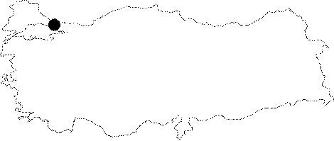 |
For photographs please click on the photo... 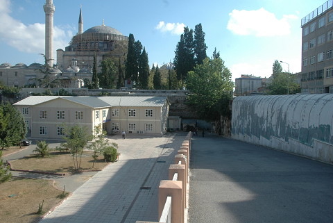 |
|
|
|
|
Type:
|
Cistern |
|
Plan Type:
|
|
|
Year of Costruction:
|
459 |
|
Phase:
|
Early |
|
Investigation Method:
|
|
|
Altitude:
|
60 |
|
|
|
|
Region:
|
Marmara |
|
Province:
|
Istanbul |
|
District:
|
Fatih |
|
Village:
|
Hatip Muslihittin Mah. |
|
Antique Name:
|
Constantinople |
|
|
|
 |
|
| Location: It is adjacent to the southern part of the Yavuz Selim Mosque in the Carsamba Quarter of the Fatih District in Istanbul. It is also called Sultan Selim Cukurbostani. The sepulchers of Sultan Selim and Sultan Abdülmecit I are located to the northwest. |
| Geography and Environment: It constituted a major part of the aqueduct and cistern system supplying water to the city during the Early Byzantine Period. At present, it has been occupied by some facilities of the Egitim Gönüllüleri Vakfi (The Educational Volunteers Foundation). |
| Research and Excavation: No systematic survey has been conducted in the cistern. |
| Description: Building Phases: The construction was initiated by Patrikios Aspar in 459. It is uncertain for how long it served as a cistern. During the 16th century, a small mosque was built inside it, and then used as a vegetable garden. At present, it has been obscured by several modern buildings and sportive fields. Architectural Features: The open cistern looks like a giant pool with a square-like rectangular plan. The overall length is approximately 152 m, and the wall height is around 10-11 m. The thick enclosure wall was built in alternating courses of stone and bricks [Müller-Wiener 2001:279, pic. 315; Forschheimer-Strzygowski 1893:46-47, pic. 2; Schneider 1936:30-31; Janin 1943; Freely-Cakmak 2004:48-49; Eyice 1993h:356-357]. |
| Finds: |
| Interpretation: |
| Destruction: The southeast cistern wall is behind the concrete construction built in front of it. The structures leaning against the walls inside the cistern were demolished; but they are still traceable. Southeast corner contains a large size electric generator. Fatih Municipality building is adjacent to the northeast wall. This building is currently being used by Ismek Kursu. An iron scaffold was built for the restoration of the northeast wall and cutting the trees. Besides these, there is a water tank in the northeast corner and a mosque for the temporary usage due to the restoration of the Yavuz Selim Mosque restoration. Part of the northeast wall was demolished to facilitate the entry of the vehicles. A 3 m long portion which composed the upper part of the wall was built in addition. There is also an iron pipe with cement poured around it which extends alongside the northeast wall. The cistern is being used as gamepark for the children, as a parking lot, and as a sports complex as well. There is a power transformer on the northeast corner and circular planned Ottoman Period building remains adjacent to the corner. The walls on all sides of the cistern are densely covered with vegetation and trees. A reinforced concrete cottage leaned up against the southwest wall. Iron fences surround the top parts of the surrounding cistern walls [TAYEx 07.09.2008]. |