|
©The Archaeological Settlements of Turkey - TAY Project
|
|
|
|
|
Khalkoprateia Kilisesi |
|
|
|
|
|
For site maps and drawings please click on the picture...  |
For photographs please click on the photo... 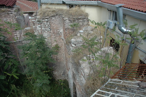 |
|
|
|
|
Type:
|
Church |
|
Plan Type:
|
Basilica |
|
Year of Costruction:
|
Middle of 5th c. |
|
Phase:
|
Early |
|
Investigation Method:
|
Survey |
|
Altitude:
|
38 |
|
|
|
|
Region:
|
Marmara |
|
Province:
|
Istanbul |
|
District:
|
Fatih |
|
Village:
|
Alemdar Mah. |
|
Antique Name:
|
Constantinople |
|
|
|
 |
|
| Location: It is situated on the Zeynep Sultan Street of the Alemdar Avenue in the Sultanahmet Quarter of the Eminönü District in Istanbul. |
| Geography and Environment: The church which was built around the mid-5th century in a region allocated to the coppersmiths and merchants tradesmen, and dedicated to the Virgin Mary (Theotokos) lies approximately 100 m west to the Church of St. Sophia. It was a very significant church for the Cult of the Virgin Mary as it was believed that it housed a girdle supposedly belonging to the Virgin Mary so that feasts were honored with the presence of the Emperor and the Patriarch. 150 m to the south stood the Augustaion Square; and to the east were the Church of St. Sophia and the Patriarch's Palace; and 50 m to southwest was the Basilica Cistern (Yerebatan). At present, the church lies under the buildings, and only the apse and its northern wall which, at the same time, constitutes a part of the southern wall of the Zeynep Sultan Mosque's courtyard are visible. |
| Research and Excavation: The excavations conducted in 1912 yielded various constructional elements [Müller-Wiener 2001:77]. W. Kleiss of the German Archaeological Institute carried out surveys in the church, and on the remains of a building with a central plan adjacent to the northwestern end between 1963 and 1965 [Kleiss 1965; Kleiss 1966]. |
| Description: Building Phases: The original sanctuary, which was built around the mid-5th century was demolished as a result of a fire in 476, and replaced by the present building [Müller-Wiener 2001:76]. After sustaining damage from an earthquake in the mid 6th century, it was repaired by Justin II. Also undergoing repairworks during the reign of Emperor Basil I (867-886) as well as between the late 13th and early 14th centuries, it was converted into a mosque in 1484. The building was damaged following the fire in 1755, the earthquake of 1766, and again during the riots of the janizaries in 1808 and 1826, and was repaired right after these events [Müller-Wiener 2001:76-77]. The minaret was brought down by the Directorate of Foundations in 1936, and the wooden roof was removed. Architectural Features: The accessible remains include the church's apse, and part of the northern nave's wall along with the remains of a centrally planned building adjacent to the northwestern corner of the church [Krautheimer 1986:105]. It is a basilical church with a wooden roof, divided into three naves by two colonnades. The apse is triangular on the outside, and circular inside [Mathews 1976:319-320, pics. 34.1-34.3]. The church remained in the middle of densely populated housing zone and only the apse and a portion of the south wall survived. The apse of the building was delimited by a wall on the west side. Therefore it appears as if it were a square planned building that measures 8x8 m. The east side contains the mihrab remains of the mosque. There are three openings on the west wall of the building. An iron door was used in the center of the round arched opening and the others were closed by laying bricks inside. In addition to the apse the south wall remained [TAYEx 02.09.2008]. Decorative Features: Frescoes dating to the 14th century were found in the centrally planned building adjacent to the northwestern corner of the church [Mango 1969-70a:369-372]. |
| Finds: |
| Interpretation: S. Eyice reports that the building adjacent to the northwestern corner of the church is not a baptistery, but a martyrion [Eyice 1993a:61]. |
| Destruction: Only the church's apse and a small portion of the south wall remained from the building which is in a housing development area starting in Ottoman Period. A small parking lot is located west of the structure. It is filled with garbage and vegetation in addition to the stuff that belong to the parking lot. Concrete buildings' roofs can be traced on the north wall where these houses were first built adjacent to the building then were demolished [TAYEx 02.09.2008]. |