|
©The Archaeological Settlements of Turkey - TAY Project
|
|
|
|
|
|
Gre Virike |
|
|
For site maps and drawings please click on the picture... 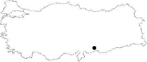 |
For photographs please click on the photo... 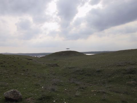 |
|
Type:
|
Mound |
|
Altitude:
|
500 m |
|
Region:
|
Southeastern Anatolia |
|
Province:
|
Sanliurfa |
|
District:
|
Birecik |
|
Village:
|
Akarçay |
|
Investigation Method:
|
Excavation |
|
Period:
|
EBA I EBA II EBA III |
|
|
|
 |
|
| Location: It lies on the road running from Birecik to the south in parallel to the Euphrates; 1.1 km northwest of the Akarçay Village; 15 km south of the Birecik District; 75 km southwest of the Sanliurfa Province [Ökse 1999a: fig.1]. It is located on the eastern bank of the river. |
| Geography and Environment: The piling of villages from various periods established on the first terrace of the Euphrates is reported to measure 15 m in height and 70x60 m in dimensions. It has been severely damaged. To the south; a section resulted from the removal of the soil is observed [Ökse 1999a:topographical plan at fig 2]. |
| History: |
| Research and Excavation: It was discovered during a survey in 1989; by a team under G. Algaze. In 1998; a more detailed survey was conducted by a team under the directorship of T. Ökse as a part of the METU TAÇDAM Salvage Project of the Archaeological Heritage of the Ilisu and Carchemish Dam Reservoirs. Excavations carried out within the same project during 1999-2001; under the leadership of T. Ökse. It takes place in the registered archaeological sites list prepared by Ministry of Culture and Tourism. |
| Stratigraphy: Painted Halaf and Ubaid Period sherds recovered from the silt and the coarse ware sherds have shown that the settlement goes back to the Chalcolithic Period. The architectural remains belong to EBA III/IV-MBA I. Two building stages and graves have been identified upon the hill; which belong to the second half of the 3rd millenium. while the late building phase was dated to EBA III-IV; the early phase was assigned to EBA II-III. The buildings with mud brick walls located on the southern slope were dated to the Byzantine Period and they represent the latest settlement. |
| Small Finds: Architecture: The 1999 excavation yielded some buildings dating to EBA III-IV/MBA I above the thick mudbrick paving/blockage built as a terrace [Ökse-Bucak 2001:192-193]. During the construction of this 2 m thick terrace; big stones (basalt) were used in the substructure while the superstructure was built of neat mudbrick and clay filling. 7 building levels belonging to EBA III-IV/MBA I was identified. The presence of buildings up to 1 m thick exposes that there are significant structures in these levels. They have stone foundations. During the 2000 season; the excavations were continued on this mud brick pavement. The western edge of the pavement was formed in steps; and on the northeast corner three large basalt blocks supporting the pavement were encountered. The fact that the gravel terrace appears between two parts of the pavement; between which there is an average distance of 2 m; has shown that the floor was constructed in independent sections. In the same area was found a 7 m long; 1.60 m wide and 1 m high basalt wall; which probably supported a part of the pavement. Two large and three small plastered holes appearing in this part of the pavement indicate the existence of some light construction; such as a trellis. To the north; there is an area with traces of lime plaster of 6 cm in thickness. Upon a layer of clay 6 cm in thickness on this area's floor; there is a layer of ashes 2-5 cm in thickness; while on the upper part is situated a heap of earth mixed with clay and ashes and with mud brick rubble. Similar plastered areas; among which there is a difference in elevation of about 1 m; extend in the same direction as the paving [Ökse 2002:271;272]. On the western section of the settlement; were exposed four independent structures extending in north northeast-south southwest direction. Intervening spaces; paved with stone and an average width of 80 cm; are left between them and to the east there is a gravel-paved corridor bordered with stones. On the eastern section; there is a single roomed structure with a window on its western wall and stone paved work areas in both the northeast and southwest corners. A thick layer of ash was identified on the deepest floor reached in this section. In trench J9; were found two areas with limestone walls; extending in the same direction as the mudbrick pavement. In the western section; there is a 55 cm thick stone wall founded on the gravel was recovered. The mud brick upper structure; the door giving access to the room from the west; the treshold with holes and doorframe of this wall was preserved [Ökse 2002:272-274]. On the southwestern slope of the mound; basalt blocks extending in three steps were revealed. These blocks were placed one upon the other in 4-5 courses. On the southern slope of the mound; a channel filled with grain was found. The top and the floor of it were constructed with basalt blocks. There are also three pits in this area. They were bonded with partly basalt and partly limestone blocks and covered with basalt slabs. Grain and ashes were found in the holes on the clay plaster between the basalt slabs. The sherds of high pedastelled coarse ceramics with incised grooves were found around these pits and were assigned to the first half of the 3rd millennium BC. The destructed basalt structure on the southern slope was excavated and from between the stones was revealed a stepped tunnel. This structure; which probably was going down to the underground water source; according to the ceramics; collapsed at the end of the EBA and was not used afterwards. These stepped structures that are also known from Gedikli Karahöyük and Kiriskal Höyük had a usage related to the burials during the 3rd millenneum BC [Ökse-Bucak 2003:360;361]. Pottery: During the analysis of the finds collected from the surface by A. Ökse; the sherds were separated into subgroups such as simple plain ware (standard ware/einfache ware); fine tempered ware; fine sandy ware and fine-pasted ware. These wares are common in North Syria and Southeastern Anatolia. This group of ware was used from EBA I to IV. Likes of them are seen at the settlements of Taskun Kale; Asvan Kale; Kurban Höyük level IV; Hayaz Höyük; Samsat and phases G-I of the Amuq Plain. A second major group of ware recovered during the surface collection is metallic ware (stone ware). It is wheel-made and very well fired. The paste is elaborately prepared. The ones recovered from Gre Virike are the samples of local metallic ware. Samples of this ware were found at level IV of Kurban Höyük; Hayaz Höyük; Samsat; Harran; cemetery of Lidar Höyük and among the grave goods of Karkamis Acropolis. A sub-category of metallic ware is the vessels identified as goblet-ware of which the outer surface left horizontally grooved by intention. They are dated to EBA III [Ökse 1999a:]. Samples of coarse kitchenware were also collected from the surface as well as the sherds bearing incised decorations. The latest publication of the excavation reports the presence of reserved slip decorated ware; although rare; and samples of Karaz ware probably dating to the first half of the third millennium BC. The ceramic finds encountered during the 2000 season include EBA III and IV wares such as a conical goblet; a goblet with a carinated body and everted rim; miniature bowl sherds made of the local metallic ware; sherds of horizontally pattern burnished vessels of standard ware and long necked jars. Clay: The head of a human figurine and a hindquarters fragment of a quadupedanimal figurine made from baked clay were found. Chipped Stone: A tanged arrowhead of triangular form and made of flint was found upon the mudbrick pavement. Ground Stone: The building level 3 of the EBA settlement yielded a building model in limestone; stone cup and stone loom weights. Human Remains: The two graves dated to EBA III-IV/MBA I by the excavator represent a distinctive burial tradition of Southeastern Anatolia. An almost oval circular pit is encircled by 4 rows of big stones capped by thick limestone plates. Probably; they were tried to be built as cist graves; but due to the shortage of the plate stones they were ended up in such a different type. The depth of the grave is 70 cm while the dimensions are 125x95 cm. It is rich in terms of grave goods [Ökse-Bucak 2001:193; pic.5-6]. The two children's skeletons were accompanied with plenty of small cups; a bird-like small bell in terra cotta; two ox-cart wheels as toys; three bronze pins and agate beads. Another interesting find of the grave is a small bath tube used as a toy. Another similar grave of an infant built of stone walls and a pithos grave evidence the intramural burial of the infants and children by the EBA society. Six other graves were revealed during the 2000 excavations. Chamber Tomb K9 was set into the mudbrick paving in the same orientation as the pavement and the structures. The tomb consists of a main tomb chamber; a passageway and an antechamber. The top of the chamber was closed with large limestone slabs. In thee upper levels of the main tomb chamber were found sherds belonging to jars broken when the chamber collapsed; this indicates that this tomb was reopened and reused several times for burials. The grave goods heaped in the western half of the main tomb chamber are; a spearhead; an agate bead; a bronze pin; a silver spiral; a tangled triangular flint arrowhead; triangular and lozenge shaped pieces of inlay made from animal shell; and 76 pottery sherds. Bone fragments belonging to more than one skeleton were found. In the antechamber; foot fragments of high fruit stands; fragments of a bronze pin and a miniature bowl and two plates; in the passageway two pins with heads were retrieved. L8 Burial was built in a form similar to K9. Inside the tomb were encountered skeletal fragments and pottery dated to EBA III. The other tomb is a mud brick cist grave. A skull and two gold leaf decorations were found inside it. The Stone Cist Grave was set damaging the northern wall of the chamber tomb. It has yielded a bronze pin and a stone bead. The Jar Burial was set into a cavity partly opened in the southern edge of K9. The jar's mouth was oriented to the north and upon the jar was a limestone lid and its neck was supported with a piece of limestone on both sides. Two miniature bowls; two small bottles and one bottle were recovered north of the jar's mouth. From within the jar were retrieved the skeleton of an infant and a bronze pin. To the southeast of tomb K9 another grave was found with a stone frame in 25 cm in thickness [Ökse 2002:274-279]. During the 2001 season; a chamber tomb was found. The limestone slabs belonging to the cover were found fallen inside the oval shaped limestone tomb. The cover was destroyed by a bulldozer and the tomb was robbed. A small amount of infant bone fragments; a bronze needle and ceramics dating to EBA IV were found close to the southern entrance. |
| Remains: |
| Interpretation and Dating: The excavations conducted between 1999-2001 have shown that Gre Virike does not include domestic structures such as large roomed buildings and storage units. The buildings are fairly small and they spead on an area limited by a mudbric pavement measuring 35x55 m. The amount of the mudbrick and the large stone slabs used for the construction of this pavement indicate that this area was used for ceremonies. The small rooms connected to the chamber tombs; the stepped structure; animal bones with cutting traces; the water channel and the pits around them are suggested to be related to some rituals of the dead cult and the beginning of the spring. The settlement probably lost this function in the 3rd millennium BC and with the storage complex built in the Medieval Age; it was used for another purpose [Ökse-Bucak 2003:362]. |