| ©The Archaeological Settlements of Turkey - TAY Project | ||||||
|
|
||||||
Gre Virike |
||||||
|
|
||||||
| Ages | Maps | Photos | ||||
| EBA |
 |
 |
||||
|
|
||||||
|
Type:
|
Mound | |||||
|
Altitude:
|
500 m | |||||
|
Diameter:
|
m- Direction: | |||||
|
|
||||||
|
Region:
|
Southeastern Anatolia | |||||
|
Province:
|
Sanliurfa | |||||
|
District:
|
Birecik | |||||
|
Village:
|
Akarçay | |||||
|
|
||||||
|
Destruction :
|
Natural causes - Agriculture | |||||
|
|
||||||
|
TAYEx:
|
Visited - 14/8/2001 | |||||
|
|
||||||
|
Registration State:
|
Registered For detailed registration information please refer to Turkish pages. | |||||
 |
||||||
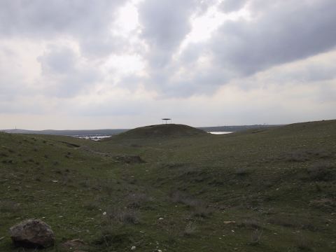
| Location: It lies on the road running from Birecik to the south in parallel to the Euphrates; 1.1 km northwest of the Akarçay Village; 15 km south of the Birecik District; 75 km southwest of the Sanliurfa Province [Ökse 1999a: fig.1]. It is located on the eastern bank of the river. |
| Geography and Environment: The piling of villages from various periods established on the first terrace of the Euphrates is reported to measure 15 m in height and 70x60 m in dimensions. It has been severely damaged. To the south; a section resulted from the removal of the soil is observed [Ökse 1999a:topographical plan at fig 2]. |
| Destruction Details: There is destruction caused by illicit diggers and soil removal on the mound which the archaeological excavations continue [TAYEx 14.8.2001]. |