|
©The Archaeological Settlements of Turkey - TAY Project
|
|
|
|
|
|
Ibonun Rampasi |
|
|
For site maps and drawings please click on the picture...  |
For photographs please click on the photo... 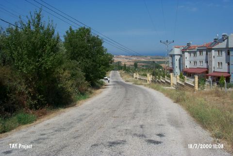 |
|
Type:
|
Habitation Site / Workshop |
|
Altitude:
|
50 m |
|
Region:
|
Marmara |
|
Province:
|
Yalova |
|
District:
|
Merkez |
|
Village:
|
Akköy |
|
Investigation Method:
|
Survey |
|
Period:
|
EP ÜP |
|
|
|
 |
|
| Location: This site lies on the southern shore of the Sea of Marmara in the province of Yalova between the center of the town and the summer resort village of Çinarik. It is about 1 km inland from the sea and about 4 km from Çinarcik. |
| Geography and Environment: The site is composed of a scattered collection of tools spread over a large 100x150 m area; on both sides of the sloping sharp bend in the road going from Yalova to Çinarcik via the village of Samali. The site has been called "Ibonun Rampasi" after the local name for this bend in the road. |
| History: |
| Research and Excavation: The site was discovered by Güven Arsebük and other members of the University of Istanbul; Faculty of Letters; Prehistory Section. The survey was not systematically conducted. The finds suggest that there must be Palaeolithic and later habitation sites in the northern Marmara Region. |
| Stratigraphy: |
| Small Finds: Among the finds are flake-blades; scrapers on blade cores; borers and multi-functional tools with Upper Palaeolithic and some Middle Palaeolithic characteristics [Esin 1992:65; fig.2/7-8; fig. 3/9-14]. As Esin suggests; the few obsidian bladelet fragments might indicate that this site had a short Epipalaeolithic habitation [Esin 1992:65; Esin 1994:453]. |
| Remains: |
| Interpretation and Dating: |