|
©The Archaeological Settlements of Turkey - TAY Project
|
|
|
|
|
|
Incirlitepe |
|
|
For site maps and drawings please click on the picture...  |
For photographs please click on the photo... 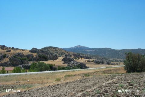 |
|
Type:
|
Flat Settlement |
|
Altitude:
|
880 m |
|
Region:
|
Mediterranean |
|
Province:
|
Isparta |
|
District:
|
Gönen |
|
Village:
|
Gümüsgün |
|
Investigation Method:
|
Survey |
|
Period:
|
Early |
|
|
|
 |
|
| The 30x100 m site lies northwest of Isparta; southeast of Keçiborlu; northeast of Gölbasi village. It is located on a 7 m high terrace; and locally called Incirlikaya. E. Bostanci; who discovered the site; claims that a probable LNA settlement is existent [Harmankaya 1997:Incirlitepe]. According to the surface collection of M. Özsait; Early Chalcolithic Age sherds; resembling Hacilar finds; were found. The site is also mentioned as Incirli 1 in archaeological publications. |
| Location: This site lies northwest of the city of Isparta; and southeast of the town of Keçiborlu. It is west of the Isparta-Burdur highway. |
| Geography and Environment: A 30x100 m area on the southern terrace of the Incirlikaya Rock outcrop; which faces the plain at the northern tip of Burdur Lake; yielded ceramics and other finds. The site has been called Incirlitepe after the local name for the place. Özsait has referred to the site as Incirli I; to avoid confusion with the nearby site of Incirli. Although the site faced much natural destruction and erosion in 1983; a thin layer of cultural material deposit still remains. The spring immediately beneath the rock-outcrop on which the site lies; must have served as a water source for the early settlers at this site. |
| History: |
| Research and Excavation: |
| Stratigraphy: |
| Small Finds: |
| Remains: |
| Interpretation and Dating: |