| ©The Archaeological Settlements of Turkey - TAY Project | ||||||
|
|
||||||
Incirlitepe |
||||||
|
|
||||||
| Ages | Maps | Photos | ||||
| Neolithic Chalcolithic |
 |
 |
||||
|
|
||||||
|
Type:
|
Flat Settlement | |||||
|
Altitude:
|
880 m | |||||
|
Diameter:
|
m- Direction: | |||||
|
|
||||||
|
Region:
|
Mediterranean | |||||
|
Province:
|
Isparta | |||||
|
District:
|
Gönen | |||||
|
Village:
|
Gümüsgün | |||||
|
|
||||||
|
Destruction :
|
Agriculture - Attention | |||||
|
|
||||||
|
TAYEx:
|
Visited - 30/6/2001 | |||||
|
|
||||||
|
Registration State:
|
For detailed registration information please refer to Turkish pages. | |||||
 |
||||||
| Location: This site lies northwest of the city of Isparta; and southeast of the town of Keçiborlu. It is west of the Isparta-Burdur highway. |
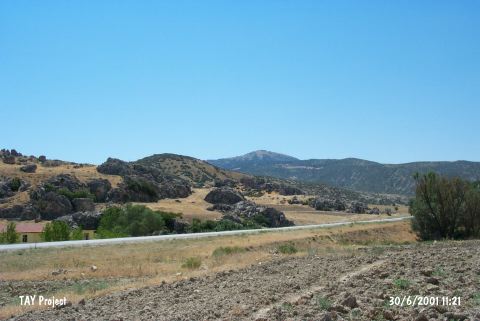
| Geography and Environment: A 30x100 m area on the southern terrace of the Incirlikaya Rock outcrop; which faces the plain at the northern tip of Burdur Lake; yielded ceramics and other finds. The site has been called Incirlitepe after the local name for the place. Özsait has referred to the site as Incirli I; to avoid confusion with the nearby site of Incirli. Although the site faced much natural destruction and erosion in 1983; a thin layer of cultural material deposit still remains. The spring immediately beneath the rock-outcrop on which the site lies; must have served as a water source for the early settlers at this site. |
| Destruction Details: The mound has been damaged due to agricultural activities. It is completely plowned [TAYEx 30.6.2001]. |