|
©The Archaeological Settlements of Turkey - TAY Project
|
|
|
|
|
|
Kaledorugu / Kavak |
|
|
For site maps and drawings please click on the picture...  |
For photographs please click on the photo... 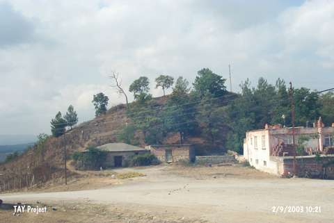 |
|
Type:
|
Mound |
|
Altitude:
|
685 m |
|
Region:
|
Black Sea |
|
Province:
|
Samsun |
|
District:
|
Kavak |
|
Village:
|
Merkez |
|
Investigation Method:
|
Excavation |
|
Period:
|
EBA II |
|
|
|
 |
|
| Location: It is located in Yeni Cami Quarter of Kavak District; some 40 km south of the Samsun Province. It is mistakenly introduced as Kavak in some publications. It can be easily reached through the Samsun-Kavak motorway. |
| Geography and Environment: It is an oval hill with steep slopes. It measures 25 m in height and 350x250 m in dimensions. It stands on a rocky block surfacing on the southern and eastern parts. The Aglidere Stream flows next to the mound. It overlooks the Kavak Plain on the south. It is located on a natural road reaching to Havza; Amasya from Samsun. It has been destroyed due to illicit diggings. The top hill has been flattened. Remains of a fortress are observed on the surface. |
| History: |
| Research and Excavation: It was excavated by K.Kökten; T. Özgüç and N. Özgüç in 1940-41 following the excavations of Dündartepe- Tekeköy. The northern; eastern slopes and top hill were investigated. The bedrock was reached in the slope settlements. It was visited by U.B. Alkim in 1973 and S. Dönmez in 1997. It takes place in the registered archaeological sites list prepared by Ministry of Culture and Tourism. |
| Stratigraphy: The excavation yielded remains of the Ottoman-Seljuck and the Byzantine-Roman periods mixed in a deposit of ca. 2.70 m thick in the upper levels followed by the levels from Hittite Period from 2.70 m to 3.92 m; as defined by the excavators. The architectural remains have been damaged by the upper levels. The EBA level starting after ca 4 m reaches the bedrock. However; a slightly different stratification was revealed in the slope trenches where the third level is dated to the Hittite Period and fourth level to the EBA (Copper Age by its former name). The bedrock was reached at 4.85 m. The thickness of the EBA level is supposed to be 1.5 m. |
| Small Finds: Architecture: The most significant settlement of Kaledorugu is the EBA settlement. A stone wall; 75 cm thick and only part of 6 m long being uncovered in the trench of the eastern slope; and an orderly staircase adjacent to this wall were recovered on the bedrock. Those remains are suggested to belong to a big building [Kökten et al. 1945:391]. No explanation is provided about the dating of this structure by the excavation leaders. The city wall considered belonging to the EBA settlement was not recovered in this foothill trench. Pottery: Sherds of the handmade; black; red; brown colored and burnished ware with a red interior surface and a black exterior surface or vice versa was recovered. Very well burnished black surface colored vessels bear groove decorations. They are decorated with white fillings as well. Also jagged and coarse incision decorations are seen on red; brown and black vessels. Likes of those jagged decorated vessels are recovered from Dündartepe; Alacahöyük and Pazarli. Only a few samples of the ware with white painting decorations on a black wash were found. Particularly a grave good decorated with triangular patterns is a good representative of long necked vessels. Forms of dishes; bowls; plates; jugs and pithoi represent the other samples of this age. Also found are knob shaped handles as well as handles resembling the idol heads. Ground Stone: Presence of finds like shaft-holed axes; shaft-holed hammer axes is reported. Metal: A rivet pierced dagger identical to the ones left as grave goods at Tekeköy was recovered. Human Remains: 12 skeletons found in the eastern trench and 1 skeleton found in the northern trench indicate the presence of an intramural cemetery. T. Özgüç reports that it is a single-phased cemetery and it covers an area of 14x12 m [Özgüç 1948:58]. It is also informed that the graves were placed in order. It was established in the eastern part of the EBA settlement. It is dated to the first and middle phases of the Copper Age as reported by T. Özgüç. Simple pit burials were preferred. Some pits were opened into the bedrock. The bodies were buried in hocker position. Heads face the southwest and feet face the northeast. Analysis on skeletons revealed that there are both adult and infant burials. Grave goods include jugs; vessels and metallic finds. Exposure of lots of ashes; despite the fact that none of the bones were burnt; in one of the graves resulted in various interpretations by the excavators; e.g. cremation. Copper-bronze daggers were found on the right arms of the dead. Some were recovered undamaged. However; one of them was damaged as it was bended three times. The reason of this conscious damage couldn't be understood. |
| Remains: |
| Interpretation and Dating: Even tough it has a monumental appearance with the natural rocky hill beneath; Kaledorugu is a small mound. It has a significant position since it is located on the natural alleys passing from the coastal Black Sea region to Central Anatolia. The biggest and most significant settlement of the mound is the EBA settlement. It probably houses buildings of a local architecture. It was surveyed in a short period of time like the many other mounds in the vicinity of Samsun except Ikiztepe. The cemetery is near the houses in the same level. The finds of Kaledorugu can be dated to the EBA I and II in parallel with the settlements of Dündartepe and Tekeköy. |