| ©The Archaeological Settlements of Turkey - TAY Project | ||||||
|
|
||||||
Kaledorugu / Kavak |
||||||
|
|
||||||
| Ages | Maps | Photos | ||||
| EBA IA |
 |
 |
||||
|
|
||||||
|
Type:
|
Mound | |||||
|
Altitude:
|
685 m | |||||
|
Diameter:
|
m- Direction: | |||||
|
|
||||||
|
Region:
|
Black Sea | |||||
|
Province:
|
Samsun | |||||
|
District:
|
Kavak | |||||
|
Village:
|
Merkez | |||||
|
|
||||||
|
Destruction :
|
Contemporary Settlements - Highways, roads, bridges etc. - Attention | |||||
|
|
||||||
|
TAYEx:
|
Visited - 2/9/2003 | |||||
|
|
||||||
|
Registration State:
|
Registered For detailed registration information please refer to Turkish pages. | |||||
 |
||||||
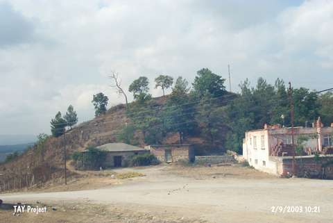
| Location: It is located in Yeni Cami Quarter of Kavak District; some 40 km south of the Samsun Province. It is mistakenly introduced as Kavak in some publications. It can be easily reached through the Samsun-Kavak motorway. |
| Geography and Environment: It is an oval hill with steep slopes. It measures 25 m in height and 350x250 m in dimensions. It stands on a rocky block surfacing on the southern and eastern parts. The Aglidere Stream flows next to the mound. It overlooks the Kavak Plain on the south. It is located on a natural road reaching to Havza; Amasya from Samsun. It has been destroyed due to illicit diggings. The top hill has been flattened. Remains of a fortress are observed on the surface. |
| Destruction Details: Village houses were built on the north-northeastern skirt of the mound. Its eastern skirt was cut by an asphalt road [TAYEx 2.3.2003]. |