|
©The Archaeological Settlements of Turkey - TAY Project
|
|
|
|
|
|
Norsuntepe |
|
|
For site maps and drawings please click on the picture...  |
For photographs please click on the photo... 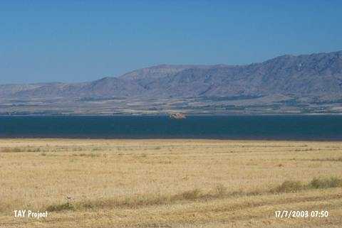 |
|
Type:
|
Mound |
|
Altitude:
|
885 m |
|
Region:
|
Eastern Anatolia |
|
Province:
|
Elazig |
|
District:
|
Merkez |
|
Village:
|
Alisam |
|
Investigation Method:
|
Excavation |
|
Period:
|
EBA I EBA II EBA III |
|
|
|
 |
|
| Location: The site is located 26 km southeast of Elazig; within the geographical triangle of the villages of Alisam (Harmanpinari); Yukari Aginsi (Elmapinar); and Asagi Aginsi (Kavakalti). It is 3 km south of the village of Alisam. The mound has become an island in the reservoir of Keban Dam after 1975 and now is vanishing slowly. The name is local and the location code is O 54 / 8. |
| Geography and Environment: The conical; 150x130 m mound with a height of 35 m used to be one of the larger mounds of Altinova Region. It used to cover an area of 500x300 m together with its slopes. The region is a watery and fertile plain; framed by Mastar and Bingöl Mountains and irrigated by Heringet Stream and Karasu River. Today; this plain is mostly inundated; as well. |
| History: |
| Research and Excavation: Attracting the attention of scientists conducting surveys on the plain (Kökten; Meriggi) and the travelers going from Elazig to Bitlis as it could be easily seen from the motorway; the mound was investigated in 1967 in detail by R. Whallon Jr. and S. Kantman who were surveying the area that would be flooded by the Keban Dam [Whallon-Kantman 1970:2]. The excavation; started in 1968 under H. Hauptmann in the name of the German Archaeological Institute; ended up in 1974 when the hill partly submerged. The excavation was conducted in four areas; acropolis; southern terrace; western slope and fields in parallel to its size. Building levels of EBA were uncovered in the acropolis and the slopes. The site is presented as a central settlement beside a fresh water spring to which many of the small settlements in the region are sattelites [Whallon-Kantman 1970:2]. |
| Stratigraphy: It is noted that Norsuntepe had been heavily inhabited from the Late Chalcolithic Age to the end of Iron Age. For the stratification; the following table is proposed (Please see Schmidt 1996:table at fig.4). Building level I: Middle Iron Age (Urartu Period - 8th century BC) Building level II: Early Iron Age Building levels 3-5: second millennium BC Building levels 6-8: EBA III Phase C Building levels 9-10: EBA III Phase B Building levels 11-12: EBA III Phase A Building levels 13-20: EBA II Phase B Building levels 21-24: EBA II Phase A Building levels 25-30: EBA I Phase B Gap: EBA I Phase A Building levels 31-40: Late Chalcolithic Age Virgin soil |
| Small Finds: Architecture: (ascending order) EBA I: A settlement ringed with a 3-4 m thick fortification wall was uncovered [Hauptmann 1979:pic.7]. For construction; mudbrick material was employed on a stone socle. The outer surface looks like an edge of a saw. Single-room houses have clay benches; circular and cantered hearths. The constructions in the building level 26 are good examples of this type [Hauptmann 1979:pl.34]. It is noted that this building level underwent a big fire. Roof of the buildings are assumed to be of timber/reed-rush. EBA II: Building level 24 yielded a circular building with a hole for pillar in the middle as well as four-cornered buildings. Types of the houses are distinct from the previous level. Building level 23 yielded two single-roomed mudbrick buildings having a courtyard in between [Hauptmann 1982:pl.32]. Floor is of compressed clay. From building level 22; the houses are lined along a street rising up to the top hill while the buildings with thick mudbrick walls and rooms adjacent to each other are again lined along both sides of a pathway or a street in the building level 21. Hearts with ash pits reflect the way of heating and cooking. Introduction of the hut-like buildings with wood/timber pillars from the building level 18 indicates an architectural change [Hauptmann 1982:20; pl.29]. They were built 4-6 m wide positioned with a distance of 2 m to each other. The walls have pillars fenced at specific intervals. Inside walls are thickened to 15 cm by coating with white painted clay. Corners of the wooden pillared structures are rounded. Life styles inside the buildings are the same; there are hearths and benches. Their roofs are also covered by a layer of reed-rush and weed over a wooden cage. The spaces between the houses were utilized as courtyards. Next to them; mudbrick houses are seen; as well. A hearth with a horn projection uncovered in the building level 16 is one of the interesting elements of the Karaz culture. EBA III: Houses with wooden pillars were replaced by mudbrick houses again starting from the building level 14. They cover the hill in harmony with the topography. Particulary from the building level 9; the excavations on both the western and eastern slopes yielded ascents; streets; pathways crossing these streets and quarters consisting of mudbrick houses with terraces alongside the streets [Hauptmann 1982:pl.28]. Between the houses; there are detached courtyards. The urbanization is clear. The constructions of the building levels 9 and 8 [Hauptmann 1979:pl.39] were also utilized in the building level 7 with minor changes. The palace erected in the building level 7 is the oldest palace in this region. The cellar; 4x7 m in dimensions; houses 21 pieces of storage jars for cereals or liquids. They were interred up to their mouth into the ground. Houses of the building level 7 have remains of sitting benches; ovens and hearths similar to the previous levels. The triple horseshoe-like hearth uncovered in one of the rooms evidences the possibility of a religious place. Most common raw material of the houses is mudbrick. The inhabitants placed stone plates onto the substructure of the mudbrick walls in order to minimise the damage caused by the rain. Building level 6 has a monumental and remarkable building constructed on the remains of the building level 7. The new palace is a very big building in 2700 square meters. It is dated to the EBA IIIb. It has a plan comprising group of rooms with various functions built around a courtyard. To the northeast of the courtyard lies a group of construction with 12 rooms; 15x25 m in dimensions. Four of the rooms on the far north yielded 25 big pithoi orderly placed. It is clear that the sizes of the structure and the pithoi were calculated accordingly. They are all buried into the ground up to their neck. It is suggested that these four pithos-structures were entered through a hole opened from the second story based on the fact that there are no pathways in these structures. Pithoi were most probably produced for storing food as it was the case in the palace of the previous level. They were buried into the ground to take the material out easily as well as the easy stuffing. To the south of these structures lies another construction group of eight built side by side in groups of four fronting on the courtyard. They house four-cornered hearths in the center; and are thought to be employed as bedrooms in winter time. Inside; benches and several things for daily use were recovered. Two rooms on the east are certainly used as kitchens with their big and small ovens. To the east of this construction lies another group of rooms adjacent to the building. Some rooms were utilized as workshops; some as kitchens. To the west of the courtyard lies another construction group of eight. Behind it; there is a big terrace building. The ascent between this terrace building and the house constructed on a slope to the west becomes a street going to the palace on the northern section. The palace has multi-entrances. It dates to 2200 BC This palace is a proven fact that there were monumental mansion-like palaces in Eeastern Anatolia during that period. It is certain that this building was owned by a ruler or someone living in Altinova [Hauptmann 1979:pl.37]. It is suggested that the settlement was crowded residing both on the slopes and the lower city. Pottery: (ascending order) EBA I: The pottery of building levels 26 and 25 is produced of the wheel-made; light colored; fine ware (simple plain ware) and the reserved slip decorated ware. They are compared with Phase G of the Amuq Plain. Vast majority of them is the light colored fine ware. Both impressed and incision decorations were applied together on the reserved slip decorated ware. Forms of thin-walled cups; small bowls and "cyma recta" shaped cups are common. Vessels of exteriorly and interiorly burnished surfaces and rims; resembling the blackish red ware of EBA I of Central Anatolia were recovered [Hauptmann 1982:pl.25]. The lower portion of their exterior surface varies between red brown and light brown. EBA II: A change is observed in the pottery industry starting from the building level 24. Samples of the light colored fine ware decrease from 20% to 10%. Building level 21 yielded a few sherds only. Ware group identified as the black burnished Karaz/Kura-Aras/Early Transcaucasian ware is introduced. They are called Khirbet-Karak ware by some scientists. The Nahçevan/Nakhichevan handled cups and lids appear at building level 23 and disappear at 21. It is noted that number of relief and groove decorated Karaz ware increases a lot. Another original feature in the pottery of this phase is the introduction of the vessels with painting decorated ware. Karaz decorations were imitated as decorations just lik e the forms. Presences of two samples; slightly different; in painting decoration ware are reported [Hauptmann 1982:pl.26]. A wheel-made; brown colored ware is observed in building level 23; but in small amounts. In the upper levels; plastic decoration decreases to be replaced by incision decoration. EBA III: Besides variations of the black burnished Karaz ware; the painting decorated ware is recovered in a percentage of 20%. Vessels decorated with a black or brown paint on a light colored background were improved during this period. Decorated cups in the building levels 9 and 8 bear only diagonal incisions crossing each other along its rim. In the building level 7; decorations get larger and becomes prominent. In the building level 6; decorations are applied by filling simple cross-hatchings and lines between the wide bands. Also found are sherds of the wheel-made brown or grayish brown ware with red painted rim. Very limited number of samples of the Cappodacian painting decorated ware proves the intensity of the trade at the end of EBA between Eastern and Central Anatolia. Clay: Sacred (?) hearths called andiron are amazing among the movable finds of clay. Plenty of human and animal figurines were recovered. They don't have distinctive characteristics for entire periods. Small wheels for carts (toy?); coarse "çeç" seals; brush handles; etc. were recovered. The number of seals is poor. Chipped Stone: This industry of Norsuntepe was examined by K. Schmidt in detail [Schmidt 1996:]. Besides flint; obsidian was also employed as a raw material. Tools pack of EBA has weapons and tools like spearheads; scrapers; piercing tools; blades and sickles-knives. The "Cannaanean-like" long blades with wide cutting wings are rich in number. Spearheads are seen in various different types like equilateral quadrangles; triangles; short and long wings. Metal: Crucibles appearing from the building level 26 increase in number from the building level 21. The building level 25 yielded evidence for arsenical copper work. A blast furnace was found in the building level 21. Finds of moulds revealed that the EBA inhabitants of Norsuntepe were casting inside the settlement. An example of this is a bilateral (twin) mould recovered from a single-roomed house in the building level 20. In the building levels 21-14 identified as the period of wooden pillared houses; number of bronze finds increases. Bronze finds are rings; bow-tie headed and double spiral headed pins. Human Remains: An infant buried into a pithos with a triangular lug recovered from the building level 26 is the only burial of this level. The EBA cemetery of Norsuntepe was not revealed during the excavations carried out in the fields under the hill. Fauna: Analysis yielded hunting of animals like wild sheep; bezoar goat and gaur in the building levels 30-25 while the number of domestic animals increase in number in the building levels 24-21 compared to the lower levels; and cattle becomes dominant than sheep and goat. |
| Remains: |
| Interpretation and Dating: Norsuntepe is a milestone in the archaeology of the Altinova-Elazig region by its detailed excavation and publication. The excavations were conducted in a large area than the other EBA settlements in the region. Its stratification sequence contributed much to the significance of the settlement. When its neighborhood relations are taken into consideration; it is noted that the site was associated with the Northern Syria-Mesopotamia region during EBA I. Depending on the changes in the architecture and small finds; it is stated that a new community was settled in Norsuntepe from the building level 24 while the last phase housed a culture functioned as a bridge between Mesopotamia and Central Anatolia. The most significant building of the city during the last phase is a magnificent palace. It is the best indication of the improvement in the city. Arranging the palace and the houses settled on the hill by means of streets and pathways is a certain evidence of an urbanization plan. Therefore; it can be claimed that the settlement was the capital of the Altinova Plain. |