| ©The Archaeological Settlements of Turkey - TAY Project | ||||||
|
|
||||||
Norsuntepe |
||||||
|
|
||||||
| Ages | Maps | Photos | ||||
| Chalcolithic EBA IA 14C |
 |
 |
||||
|
|
||||||
|
Type:
|
Mound | |||||
|
Altitude:
|
885 m | |||||
|
Diameter:
|
m- Direction: | |||||
|
|
||||||
|
Region:
|
Eastern Anatolia | |||||
|
Province:
|
Elazig | |||||
|
District:
|
Merkez | |||||
|
Village:
|
Alisam | |||||
|
|
||||||
|
Destruction :
|
Dams | |||||
|
|
||||||
|
TAYEx:
|
Not visited - 15/8/2003 | |||||
|
|
||||||
|
Registration State:
|
For detailed registration information please refer to Turkish pages. | |||||
 |
||||||
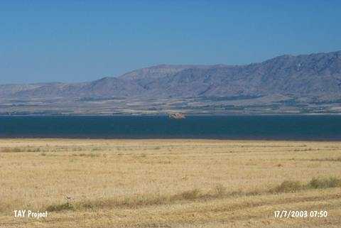
| Location: The site is located 26 km southeast of Elazig; within the geographical triangle of the villages of Alisam (Harmanpinari); Yukari Aginsi (Elmapinar); and Asagi Aginsi (Kavakalti). It is 3 km south of the village of Alisam. The mound has become an island in the reservoir of Keban Dam after 1975 and now is vanishing slowly. The name is local and the location code is O 54 / 8. |
| Geography and Environment: The conical; 150x130 m mound with a height of 35 m used to be one of the larger mounds of Altinova Region. It used to cover an area of 500x300 m together with its slopes. The region is a watery and fertile plain; framed by Mastar and Bingöl Mountains and irrigated by Heringet Stream and Karasu River. Today; this plain is mostly inundated; as well. |
| Destruction Details: The mound is flooded by dam reservoir [TAYEx 15.8.2003]. |