|
©The Archaeological Settlements of Turkey - TAY Project
|
|
|
|
|
|
Pinarbasi |
|
|
For site maps and drawings please click on the picture...  |
For photographs please click on the photo... 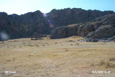 |
|
Type:
|
Rock Shelter and Flat Settlement |
|
Altitude:
|
1085 m |
|
Region:
|
Central Anatolia |
|
Province:
|
Karaman |
|
District:
|
Merkez |
|
Village:
|
Ortaoba |
|
Investigation Method:
|
Excavation |
|
Period:
|
Ceramic Aceramic |
|
|
|
 |
|
| Location: This site lies 39 km; as the crow flies; north-northwest of the city of Karaman and between 5 and 5.5 km northwest of the village of Süleymanhaci and approximately 7 km north-northeast of village of Ortaoba. |
| Geography and Environment: The rock-shelter site lies north of the city of Karaman; in the district of Pinarbasi; on the northwestern extension of limestone rock outcrop Mount Bozdag; the northwestern part of 2;271 m high Mount Karadag. Artifacts were found in the rock-shelters located at the lower parts of these limestone cliffs and in the flat area in front of the rock-shelters in front of Eski Hotamis Lake; now dried. The Neolithic inhabitants of this area must have chosen this site for its attractive location by a lake and two springs. They must have used the natural resources in this area; hunted the wild animals and used the wild grains. |
| History: |
| Research and Excavation: Surface surveys were conducted in this area after the Çatalhöyük Neolithic excavations resumed in 1993. Pinarbasi was discovered during one of these surveys which was conducted in the east part of the site as French and Hillman had suggested. Excavations at this site began in 1994 under the direction of T. Watkins and the supervision of the University of Edinburgh and the Karaman Museum [Watkins 1995a:9-11]. Core samples were collected from Süleymanhaci Lake close to the rock-shelters in order to determine the ecological situation of the Pinarbasi Region from 11000-5000 BC [Roberts 1996:376-377]. Excavation continued in 2003 with the participation of D. Baird in order to ascertain the data of 9th millennium BC settlement and to establish a little more about the nature and date of the EBA and Roman-Byzantine occupations on the site [Baird 2003]. It takes place in the registered archaeological sites list prepared by Ministry of Culture and Tourism. |
| Stratigraphy: Excavations in the Pinarbasi Region were conducted in two areas: Area A/Open Air Site: Initial excavations determined that the earliest three layers of the nine discovered in total are Early Neolithic. Area B/Rock Shelters: A total of seven stratigraphic layers were found in the excavations conducted in Area B in 1994 and 1995. The upper layers of this cultural material deposit; which had been partially destroyed by treasure hunters; have been dated to the fifth and fourth millennia BC. The lower layers; on the other hand; have been assigned to the Late Neolithic Period. |
| Small Finds: Architecture: The oldest of the three Early Neolithic layers in Area A yielded three architectural structures. One of these is a round stone element; the second is a pavement constructed with small and medium sized stones and probably mud plaster; while the third is a structural element comprised of three superimposed layers. The second Early Neolithic layer yielded a child burial. The latest and third of the Neolithic phases; on the other hand; is comprised of dark brown sandy soil and yielded no architectural structures. Three trenches; Areas A; C and D; were excavated in the small mound site to the west of the rock shelter area. These indicated that 9th millennium BC occupation is to be found over most; if not all; the area of the current small mound; probably covering c. 0.25 hectares. Area A was a continuation of the trench started in 1994. 9th millennium BC occupation is also at least 0.7 m deep in Areas A and D suggesting an intensity and longevity to the settlement. Two trenches; A and D; revealed evidence for 9th millennium structures and features. Structures incorporated a number of different elements. Since no structure has been completely excavated we are unclear as to whether these different element relate to a series of similar structures or whether buildings might have been quite diverse in character. These elements include large curvilinear plaster lined cuts (an example was exposed in Trench D). In addition some structures appear to have had superstructures of wattle and daub character; witnessed by a mass of structural debris (Fig. 1) consisting of clay/marl lumps with impressions of reed and wood in the south west corner of Area A. A number of features suggest a rectangular clay/marl pillar could also be part of a 9th millennium structure. This is located in the eastern part of Area A. However since it may sit in a cut and is located in the upper part of the 9th millennium sequence we cannot completely rule out that it might be EBA in date at this stage of excavation. Area A showed other evidence of 9th millennium BC activity. In the south east of the trench a large flattish stone had been placed. Overlying the wattle and daub debris in the south west corner of the trench a hollow appears to have been filled with a mass of cobbles and animal bone; mostly aurochs and equid [Baird 2003]. In Area B the area above the treasure hunters trenches have been as defined having small ovens and numerous fire-pits. C-14 samples from this layer has date to the fifth and fourth millennia BC The lower part of this layer has been destroyed by a Byzantine burial. A wall constructed by three or four rows of large stones found in this layer is believed to be Neolithic in date. The 7th millennium Neolithic occupation in the rock shelter is compared to the later phases of Neolithic Çatalhöyük. It included a curvilinear structure cut into the underlying deposit with stones along the top. This structure contained hearths, ovens and fire pits [http://cat.une.edu.au/page/pinarbasi; 16.11.2009, 14:30]. Chipped Stone: The open air site in area A yielded obsidian and flint chipped stone tools which have been assigned to the early Neolithic Period. In addition to obsidian; unlike in the rock shelter; flint was used in chipped stone tool production. Geometric tools are relatively low in number. The existing ones are long; asymmetric triangle-like microliths [Watkins 1996:53;55]. In Area B; the microlithic and bladelet industry is different than that in Area A. Analysis is in progress [Watkins 1996:53;55]. In 2005 season, the Epipalaeolithic material from the rock shelter (Area B) confirmed the dominance of obsidian in the chipped stone assemblage. There was little evidence of on-site knapping of microliths in the rock shelter but considerable evidence of this activity during the later Epipalaeolithic at the open site (Areas A and D). Many different types of microliths were produced, and residue sorting also produced small green stone axes and fragments of decorated stones that had been treated so that the surface color was altered [http://cat.une.edu.au/page/pinarbasi; 16.11.2009, 14:30]. Ground Stone: The decorated whetstone recovered during excavations in Area A resembles the ground stone tools found at this site during the 1993 surface survey. The ground stone tools in Area A include grinding stones; mortar fragments; a celt found beneath the child burial in the second Neolithic layer; a basalt object and a basalt grinding stone [Watkins 1996: 53; 54]. Human Bones:A burial was unearthed containing human bones near the burial of a 10 year old that was dug in 1994 above the 9th Millenium BC. It is assumed that this area is a small cemetery. The skull of this 18-20 year old skeleton is missing and the skeleton bones were tied tightly together. There is obsidian remain concentration in the south of this skeleton. In 2005, while study of the human remains indicates the adult males were particularly muscular and wear on the teeth of one individual suggests they used their teeth as tools [http://cat.une.edu.au/page/pinarbasi; 16.11.2009, 14:30]. Bone/Antler: The bone tools are comprised of a spatula fragment and the tip of a bone needle. Faunal: Area A yielded well preserved cattle; horse; bird and a few fish bones. Area B; on the other hand; yielded cattle; horse (Eqqus hydrontinus); small mammal bones; bird; turtle; snake; fox; hare as well as sheep and goat bones [Watkins 1996:55;56]. In 2005, the number of fish bones identified suggests fishing was an important activity [http://cat.une.edu.au/page/pinarbasi; 16.11.2009, 14:30]. Floral: Although the analysis of the flora is still in progress; a few seeds and a carbonized wood fragment are reported to have been found. There is still no evidence of the ancestors of cultivated cereals in this area and the population appears to have concentrated on the collection of nuts (almond and terebinth) [http://cat.une.edu.au/page/pinarbasi; 16.11.2009, 14:30]. |
| Remains: |
| Interpretation and Dating: This open-air site and rock shelter at Pinarbasi were both inhabited in the Neolithic Period. Calibrated 14C dates for Area A date to the second half of the eighth millennium BC while 14C dates for Area B date to the sixth millennium BC. |