| ©The Archaeological Settlements of Turkey - TAY Project | ||||||
|
|
||||||
Pinarbasi |
||||||
|
|
||||||
| Ages | Maps | Photos | ||||
| Neolithic EBA 14C |
 |
 |
||||
|
|
||||||
|
Type:
|
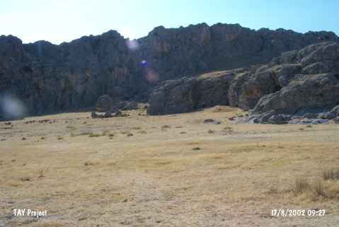
Rock Shelter and Flat Settlement | |||||
|
Altitude:
|
1085 m | |||||
|
Diameter:
|
85 m- Direction: NE-SW | |||||
|
|
||||||
|
Region:
|
Central Anatolia | |||||
|
Province:
|
Karaman | |||||
|
District:
|
Merkez | |||||
|
Village:
|
Ortaoba | |||||
|
|
||||||
|
Destruction :
|
Illicit Digging | |||||
|
|
||||||
|
TAYEx:
|
Visited - 17/8/2002 | |||||
|
|
||||||
|
Registration State:
|
Registered For detailed registration information please refer to Turkish pages. | |||||
 |
||||||
| Location: This site lies 39 km; as the crow flies; north-northwest of the city of Karaman and between 5 and 5.5 km northwest of the village of Süleymanhaci and approximately 7 km north-northeast of village of Ortaoba. |
| Geography and Environment: The rock-shelter site lies north of the city of Karaman; in the district of Pinarbasi; on the northwestern extension of limestone rock outcrop Mount Bozdag; the northwestern part of 2;271 m high Mount Karadag. Artifacts were found in the rock-shelters located at the lower parts of these limestone cliffs and in the flat area in front of the rock-shelters in front of Eski Hotamis Lake; now dried. The Neolithic inhabitants of this area must have chosen this site for its attractive location by a lake and two springs. They must have used the natural resources in this area; hunted the wild animals and used the wild grains. |
| Destruction Details: The site has been partly damaged due to illicit diggings [TAYEx 17.8.2002]. |