|
©The Archaeological Settlements of Turkey - TAY Project
|
|
|
|
|
|
Taraççi |
|
|
For site maps and drawings please click on the picture...  |
For photographs please click on the photo... 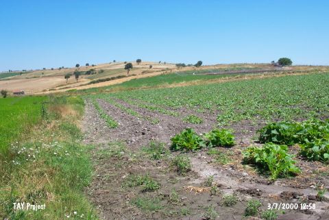 |
|
Type:
|
Mound |
|
Altitude:
|
21 m |
|
Region:
|
Marmara |
|
Province:
|
Balikesir |
|
District:
|
Gönen |
|
Village:
|
Körpeagaç |
|
Investigation Method:
|
Survey |
|
Period:
|
Ceramic |
|
|
|
 |
|
| Location: The mound-site is north of Balikesir and lies close to the village of Ayvalidere and 2.5 km west of the village of Körpeagaç; a municipality of the Gönen district. The site also lies along Gönen Stream. This area is also known as Halkali Mevkii. Code H 7 / 6. |
| Geography and Environment: The mound has been destroyed recently since many sites in this region have been leveled by a grader. It has been reported that the conical part of the mound has disappeared. |
| History: |
| Research and Excavation: The site was discovered in 1989 by M Özdogan during his survey in the Marmara Region. |
| Stratigraphy: In addition to finds from the second half of the Late Neolithic; the site yielded Yarimburgaz 4; Besiktepe; Kumtepe Ib (Chalcolithic); Troy I (Early Bronze Age); and Classical finds. |
| Small Finds: Pottery: It has been reported that the pottery collected from the leveled conical part of the mound shows close affinity with Fikirtepe ware. |
| Remains: |
| Interpretation and Dating: Özdogan notes that the destruction of the site is a great loss. He mentions that Taraççi could provide a type-site stratigraphy for sites in the Marmara Region but does not provide detailed information about the finds. |