| ©The Archaeological Settlements of Turkey - TAY Project | ||||||
|
|
||||||
Taraççi |
||||||
|
|
||||||
| Ages | Maps | Photos | ||||
| Neolithic Chalcolithic EBA IA |
 |
 |
||||
|
|
||||||
|
Type:
|
Mound | |||||
|
Altitude:
|
21 m | |||||
|
Diameter:
|
m- Direction: | |||||
|
|
||||||
|
Region:
|
Marmara | |||||
|
Province:
|
Balikesir | |||||
|
District:
|
Gönen | |||||
|
Village:
|
Körpeagaç | |||||
|
|
||||||
|
Destruction :
|
Illicit Digging - Agriculture - Highways, roads, bridges etc. | |||||
|
|
||||||
|
TAYEx:
|
Visited - 3/7/2000 | |||||
|
|
||||||
|
Registration State:
|
For detailed registration information please refer to Turkish pages. | |||||
 |
||||||
| Location: The mound-site is north of Balikesir and lies close to the village of Ayvalidere and 2.5 km west of the village of Körpeagaç; a municipality of the Gönen district. The site also lies along Gönen Stream. This area is also known as Halkali Mevkii. Code H 7 / 6. |
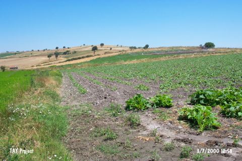
| Geography and Environment: The mound has been destroyed recently since many sites in this region have been leveled by a grader. It has been reported that the conical part of the mound has disappeared. |
| Destruction Details: The mound has been completely leveled due to agricultural activities. Traces of illicit diggings were also observed. Its southern section has been cut by the village road [TAYEx 3.7.2000]. |