|
©The Archaeological Settlements of Turkey - TAY Project
|
|
|
|
|
|
Tatarli Höyük |
|
|
For site maps and drawings please click on the picture...  |
For photographs please click on the photo... 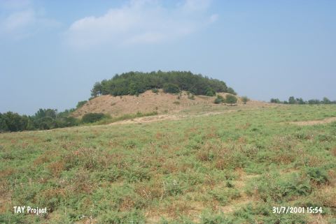 |
|
Type:
|
Mound |
|
Altitude:
|
80 m |
|
Region:
|
Mediterranean |
|
Province:
|
Adana |
|
District:
|
Ceyhan |
|
Village:
|
Kösreli |
|
Investigation Method:
|
Excavation |
|
Period:
|
Ceramic |
|
|
|
 |
|
| Location: The mound lies in Tatarli Village; 9 km northwest of Toprakkale; east of Adana Province. |
| Geography and Environment: Tatarli Höyük is a large 35 m high flat mound with a 100x75 m base. The base of the mound is basalt. There ruins of a rectangular structure lie on top of the mound. North of the mound is a swamp. |
| History: |
| Research and Excavation: The site was discovered in 1951 by M.V. Seton-Williams during his surface survey in Cilicia. It takes place in the registered archaeological sites list prepared by Ministry of Culture and Tourism. The excavations were started in 2006 by S. Girginer. |
| Stratigraphy: The finds from the surface of the mound were assigned to the Byzantine; Roman; Hellenistic Periods; the Iron; Late Bronze and Middle Bronze Age as well as the Chalcolithic and Neolithic Periods. |
| Small Finds: Pottery: Seton-Williams reports that the Late Neolithic burnished ware from the site of Tatarli Höyük shows close affinity with the Late Neolithic ware from Tatarli Höyük [Seton-Williams 1954:170]. Neither photos nor drawings of the ceramics have been published. In ASPRO; it is mentioned that painted non-Halaf ceramic was found at this site [Hours et al. 1994:338]. Chipped Stone: Both obsidian and chipped stone blades; which could not be assigned to a period; were found on the mound. |
| Remains: |
| Interpretation and Dating: The site is a difficult one to date. In ASPRO; it was placed into phase 6 (uncalibrated dates for this phase are 7;600-7;000 BP) [Hours et al. 1994:338]. |