|
©The Archaeological Settlements of Turkey - TAY Project
|
|
|
|
|
|
Tatarli Höyük |
|
|
For site maps and drawings please click on the picture...  |
For photographs please click on the photo... 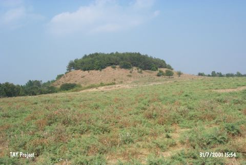 |
|
Type:
|
Mound |
|
Altitude:
|
80 m |
|
Region:
|
Mediterranean |
|
Province:
|
Adana |
|
District:
|
Ceyhan |
|
Village:
|
Kösreli |
|
Investigation Method:
|
Excavation |
|
Period:
|
|
|
|
|
 |
|
| The mound lies in Tatarli Village; 9 km northwest of Toprakkale; east of Adana Province. It is 35 m high. The diameter is ca.100 m according to the distribution of pottery. It was discovered in 1951 during the Cilicia Survey under M.V. Seton-Williams. Finds of the Neolithic; Chalcolithic; Late Bronze and Iron Ages; the Hellenistic Period and Middle Age were collected from the surface. However; it is also introduced as an EBA settlement in the survey conducted by J. Mellaart in the region. It was researched within the scope of "Adana (Ceyhan) and Kayseri (Develi) Surveys" performed by S. Girginer et al. in 2005. It is has an average height of 37 m; measuring 300x180 m in size. A wedding reception lounge was built on top of it in the near past. The top of the mound; and environs are covered with trees; and bushes. There are spring waters on the northern skirt; and inside the village. There are remain s of a Roman Bath; and pool. Many obsidian blades; and tool fragments; as well as silex tools; pottery dating to Chalcolithic Age; EBA; 2nd Millenium BC; and Roman-Byzantien Periods were revealed [Girginer 2007:177]. It takes place in the registered archaeological sites list prepared by Ministry of Culture and Tourism. |
| Location: The mound lies in Tatarli Village; 9 km northwest of Toprakkale; east of Adana Province. |
| Geography and Environment: Tatarli Höyük is a large 35 m high flat mound with a 100x75 m base. The base of the mound is basalt. There ruins of a rectangular structure lie on top of the mound. North of the mound is a swamp. |
| History: |
| Research and Excavation: |
| Stratigraphy: |
| Small Finds: |
| Remains: |
| Interpretation and Dating: |