|
©The Archaeological Settlements of Turkey - TAY Project
|
|
|
|
|
|
Tell Hasanusagi |
|
|
For site maps and drawings please click on the picture...  |
For photographs please click on the photo... 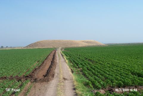 |
|
Type:
|
Mound |
|
Altitude:
|
180 m |
|
Region:
|
Mediterranean |
|
Province:
|
Hatay |
|
District:
|
Reyhanli |
|
Village:
|
Hasanusagi |
|
Investigation Method:
|
Survey |
|
Period:
|
Ceramic |
|
|
|
 |
|
| Location: This site lies 26.5 km southeast of the city of Hatay; approximately 14 km west-northwest of the town of Reyhanli; between the villages of Hasanusagi and Ömercedit. 500 m north of the mound lies the site of Hasanusagi al Dai'ah. |
| Geography and Environment: Tell Hasanusagi; which lies in the Amuq Plain; east of Lake Antioch; is a high mound with stepped terraces. The dimensions of the mound have not been provided. It is surrounded by fertile land. There is a slight depression in the western part of the mound. It is believed that the lowest levels of this mound are beneath the modern plain level. The area around the mound became marshy in the rainy season in 1933 when the site was surveyed. It has not been reported whether there are any fresh water sources close to the site. The other name of the site is Yerkuyu. |
| History: |
| Research and Excavation: The site was discovered in 1936 during the Syrian Surface Survey led by Braidwood of the University of Chicago; Oriental Institute. |
| Stratigraphy: Analysis of the ceramics revealed that the site was inhabited continually from the Neolithic to the Middle Ages. This was determined using the Tell el Cüdeyde/Judaidah ceramic seriation. |
| Small Finds: Pottery: The surface survey yielded Dark Burnished Ware similar to the ceramics from Layer XIV of Tell el Cüdeyde/Judaidah [Braidwood 1937:30]. Since the survey was not systematic; it has not been reported which side of the mound this pottery was found on (for more information on Dark Burnished Ware; see Tell el Cüdeyde/Judaidah; this volume). |
| Remains: |
| Interpretation and Dating: The site belongs to the Amuq Plain cultural sequence. The layers that show Amuq A and B affinities are believed to be at the very bottom of the mound. The mound has been placed into phases 5/6 in ASPRO like other Amuq A-B sites in this region [Hours et al. 1994:161]. |