|
©The Archaeological Settlements of Turkey - TAY Project
|
|
|
|
|
|
Tell Mahmutlu / Koyuncu |
|
|
For site maps and drawings please click on the picture...  |
For photographs please click on the photo... 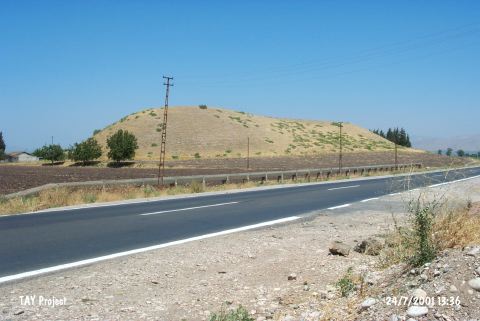 |
|
Type:
|
Mound |
|
Altitude:
|
110 m |
|
Region:
|
Mediterranean |
|
Province:
|
Hatay |
|
District:
|
Kirikhan |
|
Village:
|
Mahmutlu |
|
Investigation Method:
|
Survey |
|
Period:
|
|
|
|
|
 |
|
| It lies immediate north of the road running from Kirikhan to Muratpasa; north of Mahmutlu Village; 3 km east of Kirkhan District of Hatay Province. It is informed that it was a big and higher mound when it was discovered in 1935. The northern and northeastern parts have stepped slopes. There is no fresh water spring around. Probably when it was inhabited; the Karasu Stream was passing nearby. In accordance with the material collected from the surface by R. Braidwood; it is suspectfully claimed that the site was occupied during the EBA and the Iron Age. Another surface collection is necessary to verify the EBA finds. It takes place in the registered archaeological sites list prepared by Ministry of Culture and Tourism. |
| Location: |
| Geography and Environment: |
| History: |
| Research and Excavation: |
| Stratigraphy: |
| Small Finds: |
| Remains: |
| Interpretation and Dating: |