|
©The Archaeological Settlements of Turkey - TAY Project
|
|
|
|
|
|
Tilmen Höyük |
|
|
For site maps and drawings please click on the picture...  |
For photographs please click on the photo... 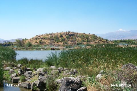 |
|
Type:
|
Mound |
|
Altitude:
|
863 m |
|
Region:
|
Mediterranean |
|
Province:
|
Gaziantep |
|
District:
|
Islahiye |
|
Village:
|
Bostanaga |
|
Investigation Method:
|
Excavation |
|
Period:
|
EBA I EBA II EBA III |
|
|
|
 |
|
| Location: The site lies approximately 10 km east of Islahiye District; in Gaziantep; 1800 m south of Bostanaga Village; north of the road leading to Islahiye. |
| Geography and Environment: Tilmen; located on a desiccated swamp area surrounded by the branches of Karasu River; is 21 m high; and measures 225 m in diameter. However; its original round shape had a diameter of 245 m before the central part extended towards west through time and the mound became ovoid as a result. It measures 200x125 m for now [Alkim 1964:169]. |
| History: |
| Research and Excavation: It was intermittently excavated between 1958 and 1972 under U.B. Alkim in the name of the University of Istanbul; Turkish Historical Society and Ministry of Culture. Particularly the first layers were opened in a wider area. The cultural layers of EBA MBA-LBA and Iron Age were found in the first trench on the uphill. However; levels of the second millennium BC were only reached at trench D opened in 1962 in the outer courtyard of the second millennium BC palace. As the excavation started in a large area followed by smaller areas in deep soundings; the architectural remains were not well revealed. The virgin soil was reached. It takes place in the registered archaeological sites list prepared by Ministry of Culture and Tourism. |
| Stratigraphy: Layer I: Islamic-Roman Periods and second millennium BC (18th-12th centuries BC). It yielded very significant structures particularly belonging to the second millennium BC of the mound. The Islamic and Roman periods are represented by pottery and small finds only. Layer II: A fortified settlement dating to the beginning of the second millennium BC was uncovered. Layer III: Building levels IIIa and IIIb are dated to the first half of 19th century BC and the second half of 18th century BC Building levels from IIId to IIIk cover EBA I-III. Layer IV: It is dated to the Late Chalcolithic Age. |
| Small Finds: Architecture (descending order): Adjacent rooms placed in a mixed order in the building level IIIc which is separated from the building level IIIb of intermediate period from EBA to MBA by a fired level provided evidence for a significant settlement. A long four-cornered room and stone walls extending from it were uncovered in IIId. Two silos with a depth of 170 cm are interesting in IIIe [Alkım 1965:8]. The structures in the building level IIIf revealed information about the settlement plan for the first time. Uneven or four cornered small rooms with small courtyards in between are observed. Based on the presence of these structures; Alkim claims that we are dealing with a significant settlement. Five silos and the northern wall of a room were revealed in IIIg. The level IIIh separated from IIIg by a thin fired level yielded fragments of stone foundations with mudbrick walls while IIIi yielded only a floor of compressed clay earth. A stand for hearth covered with sherds was uncovered in IIIj while a stone paved room and a hearth were found in IIIk [Alkım 1970:31]. When the general characteristics of all building levels were taken into consideration; houses are built on stone foundations where the outer surfaces are erected with smooth big stones and inner surfaces with uneven small stones mixed by loam mortar. They have flat roof and mudbrick walls as superstructure after at least 1 m erected by stone. A stone roller found at level IIIj supports this thesis. Between the houses; there are small courtyards. However a settlement plan couldn't be obtained due to the confined excavated area. Even tough it is unclear if there is a city wall; it can be taken for granted that the settlement is fortified compared to other EBA settlements during that period. The presence of silos built for storing wheat and barley made it certain that they were involved in agriculture. The floors of the houses are of compressed clay earth. No bench was uncovered; and no information is provided if the walls are plastered. Pottery: The excavation yielded pottery dating to EBA I-III. In the lower building levels; plenty of vessels with a red-orange color paste; product of slow-turning wheel and well burnished ware (brittle orange ware/red gritty ware) seen in the plains of Islahiye; Çukurova and Amuq from IIIj to the end of IIId was found. Sargonid-style excised sherds in gray and red sherds were revealed at IIIh and IIIg. Also found are cups called Syrian bottle. The intermediate level from EBA to MBA was reached at IIIc; the upper levels of the mound. Clay: Stamp seal; spindle whorl and loomweights were recovered. The female idol found in the building level IIId is a prototype of Syrian-like idols of the second millennium BC. Chipped Stone: Blades up to 23 cm long were recovered from the building level IIId. Ground Stone: A button-like stone seal recovered from IIIf led to date this building level to the 25th century BC. Metal: Bronze pins were recovered from the building levels. Human Remains: The burial customs of Tilmen Höyügü during this period revealed a pithos grave capped with a red-orange colored sherd and two cist graves; sides erected by stone plates in addition to the pit/chamber grave mentioned hereinbelow. The pithos grave houses an infant's skeleton. The chamber grave (M3); said to be dated to the building level IIId; has a quadrangular shape. It measures 4.15x1.55 m in outer dimensions and 2.20 m in height. Inside the grave; the floor measures 110x220 cm. The walls were erected by medium sized stones and capped with big basalt plates. The upper level of the grave was uncovered 1.80 m below the courtyard level. On both ends of the grave lie one skeleton. The western skeleton is suggested to be belonging to a female based on the ornament pins in bronze; bronze bracelet and plenty of stone beads recovered near the skeleton while the eastern male skeleton is accompanied with footed cups/vessels; probably for food; bowls and cups [Alkim 1964:175; pic.30-36] [Duru 2000f:161]. |
| Remains: |
| Interpretation and Dating: As a result of the excavation of trench D at 12 m depth; aiming to identify the stratification of Tilmen Höyügü; the excavator was able to date the layers specifically based on their relations with Mesopotamia; even tough there was no 14C samples. According to U.B. Alkim; the building level IIIc is dated to the 20th century BC and level IIId to the 22nd-21st centuries BC/EBA IIIc while the building level IIIe to the 24th-23rd centuries BC/EBA IIIb; IIIf to the 24th century/EBA IIIa; IIIg to the 26th century and IIIh to the EBA IIb or IIc. The grave M3 is dated earlier than the chamber grave of Til Barsib. The building level of IIIf is renown with its button-like stamp seals and building level IIIe with its vessels of Hama level J. Another interesting thing for U.B. Alkim is that a number; even tough a little; of Karaz/Khirbet Kerak ware recovered from EBA III. Sherds of Sargonid-type vessels found at building level IIIg is an indication of the density of the relations with Mesopotamia and Amanus region; especially during the kings of Akkads based on the presence of some Akkads bullas. Tilmen is suggested to be a significant city of the kingdom in this region during EBA. |