|
©The Archaeological Settlements of Turkey - TAY Project
|
|
|
|
|
|
Titris Höyük |
|
|
For site maps and drawings please click on the picture...  |
For photographs please click on the photo... 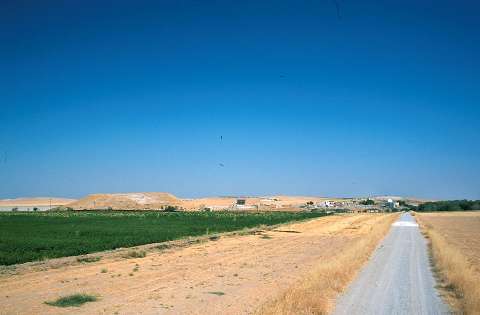 |
|
Type:
|
Mound |
|
Altitude:
|
520 m |
|
Region:
|
Southeastern Anatolia |
|
Province:
|
Sanliurfa |
|
District:
|
Bozova |
|
Village:
|
Bahçeli |
|
Investigation Method:
|
Excavation |
|
Period:
|
EBA III EBA II |
|
|
|
 |
|
| Location: It lies immediate west of Bahçeli (Titris) Village; 18 km northeast of the Bozova District; some 36 km north of the Sanliurfa Province as the crow flies [Kühne 1987:42]. It is reached through the motorway running from Urfa to Bozova by an exit to the northeast. Titris is out of the territory of the Atatürk Dam. |
| Geography and Environment: Titris is a big settlement with its mound; terraces (lower town) and extramural settlement (outer town); displaying the characteristics of a small city. The city is surrounded by a small plain which is connected to the Harran Plain and Balik Valley; i.e. the Northern Mesopotamia through a corridor extending to the south. It is assumed that a trade road running from the south and following this route reaches to Samsat over Titris via the Tavuk Stream; and then to Central Anatolia [Algaze-Misir 1993:155; fig.1]. To the southern foothill of the mound flows the Tavuk Stream; and there are many fresh water springs in the vicinity. The mound is suggested to stand on a natural limestone hill originated from Eocene. The settlement consists of a core hill/acropolis up to 22 m in height and 250x200 m in dimensions (3.3 ha.); and to the south and west of the hill; eastern and western lower town terraces; 300x180 m and 400x200 m in dimensions; respectively; assumed to cover a cultural deposit of 3-5 m thick. In addition; on the northern part there is an area measuring 2.5 m in height and 800x200 m in dimensions called the outer town as well as an extramural cemetery located ca. 400 m northwest of the mound. Furthermore; there are some workshops and a few houses like dairy farms far from the boundaries of the city (suburb). All together; the settlement reaches up to an extraordinary size of 43 ha. |
| History: |
| Research and Excavation: Titris Höyük was documented during a survey conducted by T.J. Wilkinson in 1990 and excavated under G. Algaze from 1992. The collaborative study of the Sanliurfa Archaeological Museum and the University of California continued until 1998. The excavation team didn't carry out an excavation only; but also conducted a detailed survey in the lower and outer towns. Besides; they succeeded to conduct surveys in the valley of the Tavuk Stream and its vicinity to find out 47 new settlements. Four of them were occupied all through the EBA while nine of them are dated to the middle and late periods of EBA [Algaze-Misir 1993:161-162]. It is reported that a dozen of quandrangular cist graves located at the northwestern cemetery were excavated in 1981 by the Museum of Urfa under H. Hauptmann and A. Misir for salvage purposes [Hauptmann 1993:10-15; Algaze-Misir 1993:157]. The excavations under Algaze were attended to find out the cultural stratification of the city and its expansion during the first years. The settlement plans of the lower and outer towns were obtained by means of surface excavations. The whole area of the settlement was scanned by geophysical methods and the structures identified by this method were verified by opening test trenches. |
| Stratigraphy: As a result of the excavations; the stratification of the settlement was identified. Remains of the first settlement identified as EBA I was uncovered in the uphill and its vicinity. The main urban settlement belongs to the middle (2500-2400 BC) and late (2400-2300-2200 BC) periods of EBA [Matney et al. 1999:187]. Those periods (EBA II-III) were uncovered both on the top hill and the western and eastern parts of the lower town and the outer town. The lower building levels of those two periods were identified. The excavation conducted in the mound yielded 4 layers. The building level dated to the Hellenistic Period on the eastern part of the lower town toward the modern village indicates that the site had been occupied by insignificant settlements long years after. Sherds datable to LBA; Iron Age and Roman Period were collected from the surface. |
| Small Finds: Architecture: City walls: A mudbrick wall of 3-3.5 m thick [Algaze et al 1995:pic.14] extending in the north-south direction on the eastern end of the northern part called as the "area of outer town" since it is separated from the lower town and the center of the mound by a channel is regarded as the fortification walls. The substructure of the wall is built of orderly stone blocks on a stone socle. Only a portion of 3 m high survived to present day together with the foundation. It was thickened and reinforced by the smaller rooms built inside; and probably the upper walkway was enlarged by these means [Matney 1999:fig.2]. The rooms were built as if they were embedded into the wall. It is suggested that the rooms were employed as fortifications only. Public Houses: The excavation carried out both on the western part of the lower town and the outer town yielded some units of 9 buildings completely and some partly. The settlement plans of both the lower town and the outer town were more or less identified by magnetic measurements based on the geophysical methods. This plan revealed that we are dealing with an organized city having pathways that can be called street or alley and inter-structural units. Absence of squares is very interesting. It is noted that the structural plan of the houses both in the lower town and the outer town are identical; and the units of the houses consist of multi-roomed two big wings [Matney et al. 1999:fig.2; Matney et al. 1997:fig.2]. Each room is entered through doors in various sizes. One of these doors opens to the street. Vast majority of the rooms is four-cornered. The big rooms are arranged as halls while the smaller ones like kitchen or bedrooms. The floors are of compressed clay. As construction material; flat and amorphous limestone blocks found easily in the vicinity of Titris were employed. The blocks were attached by loam mortar. The superstructures of the houses are suggested to be built of mudbrick while the roofs are assumed to be flat. Workshops: The excavation conducted in the suburb area; out of the town on the eastern part of the outer town yielded a structure where the flint was worked. This structure was built a little worse than the others; but in the same plan [Algaze et al.2000:fig.6]. Management Buildings: No structure built for this purpose was uncovered in the excavated area. It should be explored in the top hill of the settlement. Pottery: Intramural and extramural excavations yielded intact vessels and sherds presenting the pottery industry of EBA II-III of this region. Chipped Stone: A lot of flint samples were recovered form the surface; inside the buildings and the workshops at the suburb. Triangular blades in Cannaanean style and their cores were found. Those blades utilized as sickle-knives were produced in mass by a fabrication system. The presence of several handicraftsmen highlights; again; the characteristics of the settlement as a city. Metal: A mould recovered provided evidence for lead casting. This single faced mould has a cavity for goddess and small cult objects. Human Remains: The graves uncovered during the 1991-1996 excavations were examined by D. Honça in detail and dated based on the stratification and the grave goods recovered [Honça-Algaze 1998:101-142]. EBA I graves: The early phase of EBA dated to 3000-2700 BC by the excavator yielded a four-cornered cist grave in the western lower town right on the western foothill of the mound. As the area excavated is very small; it is unclear whether it is a single burial or a part of a big cemetery. The grave built by vertical flat stone plates measures 150x95 cm. An adult female was buried in hocker position into the grave. It has no door. It was capped by; again; flat stone plates. Based on the grave goods; it is suggested that the graves are comparable with Kurban level V and Hassek EBA I-II. EBA II graves: During this period where monumental structures were planned; an extramural cemetery was preferred rather than intramural graves. Three burial places were identified as a result of the excavation. Some of them were locked with big buildings during the later periods. Honçar and Algaze claim that the cemeteries were moved due to the enlargement of the settlement. Since 31 skeletons were found in 21 graves; it is suggested that some of the graves might be family graves; i.e. there might be more than one burial in some of the graves. Except one simple pit burial; all the others are four-cornered cist graves. Their dimensions vary. The single buried ones are smaller. The largest of this type measures 175x145 cm. They have neither dromos nor stone doors. Some of the family graves have single-winged doors while others have double-winged stone doors and dromos. The big stone plate on the entrance door was probably left as a marking on the earth and when a member of the family died; the capped dromos was dug and the new burial interred into the grave. The largest of these graves measures 275 x 500 cm. The construction technique is same for both types of graves. The walls of the grave were erected by overlaying flat and smooth stone plates horizontally on each other. Very big flat stones more than one piece were probably capped on the grave by means of a wooden support. The first cemetery is represented by two four-cornered cist graves dug into the virgin soil on the eastern part of the northern elevation called "outer town". They are larger than EBA I graves in size. Although one of them is a family grave with a double door and dromos; it houses a burial of 5 years old child only while the other single grave houses the burial of a 9 years old child. The excavator claims that this area is the cemetery of this phase depending on these two graves only. The second cemetery was pointed out with a single grave again dug into the virgin soil on the western part of the lower town. The four graves uncovered in 1981 on the western terrace of the lower town; not far from this cemetery are suggested to belonging to this cemetery. The third cemetery is located on a small hill on the northwest severely disturbed by the local villagers and the treasure hunters in 1981. Excavated within the same year; this cemetery yielded 29 cist graves and 3 pithos graves. 12 more graves were added by new excavations. They were all built roughly in the east-west direction. Most of them bear three burials of both adults and children. Among the small graves measuring 1x1.5 m in dimensions; there is a family grave extending up to 5 m long. At least 4 burials were found in this grave. It is difficult to understand which one was used for the first time. EBA III graves: The most well-known phase of Titris in architecture yielded three types of graves; extramural cist graves; pithos graves and intramural private graves inside the buildings. They are all 14 graves with 32 burials. The construction technique is not distinctive than the others. It can be recognized that the same burial tradition was valid all through the EBA phases. Grave Goods: Very rich grave goods were recovered from both the extramural and intramural cemeteries. The vessel inventory of this period was obtained from the cups recovered here. Syrian bottle-like vessels; footed goblets; unrolled rimmed plates and bowls were found. They were left near the dead altogether in a specific part of the grave. The personal belongings of the dead were also left as well as objects in worthy stones. The bracelet with serpentine head in silver is one of the objects worked elaborately by the goldsmiths of that period [Algaze et al. 1995:fig.32]. Bronze and silver bracelets were found near the female burials [Algaze et al. 1995:fig.31]. Also found are embossed and decorated samples of shelled sea animals like oyster [Algaze et al. 1995:30]. A dagger recovered indicates that weapons are left near the adult burials [Matney et al. 1997:fig.12]. |
| Remains: |
| Interpretation and Dating: The economy of Titris has a mixed structure dominated by the agriculture. It is claimed that the production of barley is more than the wheat. Aside cereals and corn; garden vegetables were also consumed. The vicinity during that period was probably a vineyard. Algaze refers to the inhabitants of the outer town as servants while of the lower town as public. The houses of chipped stone masters uncovered on the northwest revealed that there are small quarters occupied by the handicraftsmen whom expertise in several works around the city. There should be houses of potters and miners in the vicinity. One amazing thing is that the house of the ruler and his family was not identified yet. It might be located on the core of the uphill; but this part hasn't been documented yet by geophysical methods. The samples of violin-like idols specific to the Aegean world found at Titris provide vital evidences of the trade between the Southeastern Anatolia and Aegean regions. |