| ©The Archaeological Settlements of Turkey - TAY Project | ||||||
|
|
||||||
Titris Höyük |
||||||
|
|
||||||
| Ages | Maps | Photos | ||||
| EBA IA 14C |
 |
 |
||||
|
|
||||||
|
Type:
|
Mound | |||||
|
Altitude:
|
520 m | |||||
|
Diameter:
|
m- Direction: | |||||
|
|
||||||
|
Region:
|
Southeastern Anatolia | |||||
|
Province:
|
Sanliurfa | |||||
|
District:
|
Bozova | |||||
|
Village:
|
Bahçeli | |||||
|
|
||||||
|
Destruction :
|
Illicit Digging - Agriculture - Contemporary Settlements | |||||
|
|
||||||
|
TAYEx:
|
Visited - 4/9/2001 | |||||
|
|
||||||
|
Registration State:
|
For detailed registration information please refer to Turkish pages. | |||||
 |
||||||
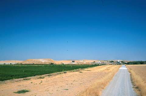
| Location: It lies immediate west of Bahçeli (Titris) Village; 18 km northeast of the Bozova District; some 36 km north of the Sanliurfa Province as the crow flies [Kühne 1987:42]. It is reached through the motorway running from Urfa to Bozova by an exit to the northeast. Titris is out of the territory of the Atatürk Dam. |
| Geography and Environment: Titris is a big settlement with its mound; terraces (lower town) and extramural settlement (outer town); displaying the characteristics of a small city. The city is surrounded by a small plain which is connected to the Harran Plain and Balik Valley; i.e. the Northern Mesopotamia through a corridor extending to the south. It is assumed that a trade road running from the south and following this route reaches to Samsat over Titris via the Tavuk Stream; and then to Central Anatolia [Algaze-Misir 1993:155; fig.1]. To the southern foothill of the mound flows the Tavuk Stream; and there are many fresh water springs in the vicinity. The mound is suggested to stand on a natural limestone hill originated from Eocene. The settlement consists of a core hill/acropolis up to 22 m in height and 250x200 m in dimensions (3.3 ha.); and to the south and west of the hill; eastern and western lower town terraces; 300x180 m and 400x200 m in dimensions; respectively; assumed to cover a cultural deposit of 3-5 m thick. In addition; on the northern part there is an area measuring 2.5 m in height and 800x200 m in dimensions called the outer town as well as an extramural cemetery located ca. 400 m northwest of the mound. Furthermore; there are some workshops and a few houses like dairy farms far from the boundaries of the city (suburb). All together; the settlement reaches up to an extraordinary size of 43 ha. |
| Destruction Details: There is a building construction on southeast slope of the mountain and a road passes through this slope. Agricultural activities are being done on the west extension of the mound this area has been terraced. The lower town of the settlement is under the contemporary village [TAYEx 4.9.2001]. |