|
©The Archaeological Settlements of Turkey - TAY Project
|
|
|
|
|
|
Üçtepe / Kerh |
|
|
For site maps and drawings please click on the picture...  |
For photographs please click on the photo... 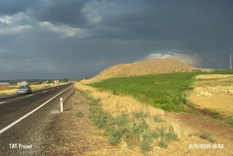 |
|
Type:
|
Mound |
|
Altitude:
|
614 m |
|
Region:
|
Southeastern Anatolia |
|
Province:
|
Diyarbakir |
|
District:
|
Bismil |
|
Village:
|
Üçtepe |
|
Investigation Method:
|
Excavation |
|
Period:
|
Early Middle Late |
|
|
|
 |
|
| The mound lies 40 km southeast of Diyarbakir; 10 km southwest of Bismil; 300 m west of the old Kerh (called Üçtepe today) village. Göksu stream; a branch of Tigris; runs west of the mound. It is 200x180 m in diameter and has a total height of 44 m together with the conglomerate elevation it lies on. The site has become famous in 1865 due to the two Assur stelea found on its surface and excavations conducted by V. Sevin have began in 1988. The excavations take place in the sections yielding rather recent periods. However; it is understood from the surface finds; not published in detail; that the mound was settled between Halaf Period and EBA. It takes place in the registered archaeological sites list prepared by Ministry of Culture and Tourism. |
| Location: It lies immediate west (200-300 m) of the former Kerh or Kerh-i Dicle Village recently named as Üçtepe located 10 km west-southwest of the Bismil District; 40 km southeast of the Diyarbakir Province [Sevin 1990:pic.2] |
| Geography and Environment: It is located on the western bank of the Göksu Stream; one of the branches of the Tigris. It stands on a conglomeratic hill. It measures 44 m in height and 200x180 m in dimensions [Sevin 1990:103-104]. Overlooking the valley of Göksu; it looks like an oval hill inclining from south to north. |
| History: |
| Research and Excavation: |
| Stratigraphy: |
| Small Finds: |
| Remains: |
| Interpretation and Dating: |