| ©The Archaeological Settlements of Turkey - TAY Project | ||||||
|
|
||||||
Üçtepe / Kerh |
||||||
|
|
||||||
| Ages | Maps | Photos | ||||
| Chalcolithic EBA IA |
 |
 |
||||
|
|
||||||
|
Type:
|
Mound | |||||
|
Altitude:
|
614 m | |||||
|
Diameter:
|
m- Direction: | |||||
|
|
||||||
|
Region:
|
Southeastern Anatolia | |||||
|
Province:
|
Diyarbakir | |||||
|
District:
|
Bismil | |||||
|
Village:
|
Üçtepe | |||||
|
|
||||||
|
Destruction :
|
Contemporary Settlements | |||||
|
|
||||||
|
TAYEx:
|
Visited - 9/9/2001 | |||||
|
|
||||||
|
Registration State:
|
Registered For detailed registration information please refer to Turkish pages. | |||||
 |
||||||
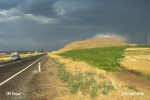
| Location: It lies immediate west (200-300 m) of the former Kerh or Kerh-i Dicle Village recently named as Üçtepe located 10 km west-southwest of the Bismil District; 40 km southeast of the Diyarbakir Province [Sevin 1990:pic.2] |
| Geography and Environment: It is located on the western bank of the Göksu Stream; one of the branches of the Tigris. It stands on a conglomeratic hill. It measures 44 m in height and 200x180 m in dimensions [Sevin 1990:103-104]. Overlooking the valley of Göksu; it looks like an oval hill inclining from south to north. |
| Destruction Details: The mound is being destructed by contemporary settlement. There are houses on east slope; a big cleft on northeast and the cemetery of village on southeast skirts [TAYEx 9.9.2001]. |