|
©The Archaeological Settlements of Turkey - TAY Project
|
|
|
|
|
|
Yayvantepe / Til Huzur |
|
|
For site maps and drawings please click on the picture...  |
For photographs please click on the photo... 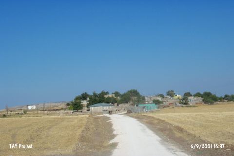 |
|
Type:
|
Mound |
|
Altitude:
|
810 m |
|
Region:
|
Southeastern Anatolia |
|
Province:
|
Diyarbakir |
|
District:
|
Ergani |
|
Village:
|
Yayvantepe |
|
Investigation Method:
|
Excavation |
|
Period:
|
Ceramic |
|
|
|
 |
|
| Location: This site lies northwest of the city of Diyarbakir; 6 km south of the town of Ergani in the village of Yayvantepe (which used to be called Til Huzur). The survey code of the site is R 56 / 1. |
| Geography and Environment: The mound; which lies in the Ergani Plain; is east of the stream which feeds this plain; the Bogazçay. The mound is surrounded by the modern village of Yayvantepe. Modern abandoned buildings continue to add to the depositional mound process. The mound is now 9 m high and has a 150x100 m base [Benedict 1980:128]. The Yayvantepe villagers have damaged the northern part of the mound for soil for mud brick construction. There are two springs close to the site; one in the north and one in the northwest. |
| History: |
| Research and Excavation: The site was discovered in 1963 by the joint University of Istanbul and University of Michigan Prehistoric Project in Southeast Anatolia. Later in 1988; the site was resurveyed by the Çayönü excavation team; under the leadership of M. Özdogan [Özdogan 1990b:462-463]. The 1990 Çayönü excavation team revisited the site under the direction of I. Caneva [Caneva 1992:128]. The assumptions that there may have been Neolithic habitation at the site because of various finds was confirmed when Dark Burnished Ware was found. Scientific excavations at the site were conducted in 1991 because of the highway construction activities in the Diyarbakir Region. This excavation was conducted jointly by the University of Rome; University of Istanbul and the Diyarbakir Museum under the direction of I. Caneva. Unfortunately; scientific excavations could not be completed due to political unrest in southeast Anatolia. The excavations were conducted in the area that had been damaged by the local villagers; who dug into part of the mound for soil for making mud bricks. A large 27x4 m trench was thus opened. This allowed for a large north-south cross-sectional profile to appear and to be drawn. It takes place in the registered archaeological sites list prepared by Ministry of Culture and Tourism. |
| Stratigraphy: The surface surveys conducted on the mound before excavations yielded Aceramic Neolithic; Ceramic Neolithic; Chalcolithic and Early Bronze Age chipped stone tools and ceramics. The southern and northern halves of the trench were different stratigraphically. The southern part yielded two Ceramic Neolithic Layers. |
| Small Finds: Architecture: The northern part of the trench yielded no architecture; although architectural remains were found in the southern part. A house which was reused and replastered many times was found in the upper occupational phase in the southern part of the trench. The plan of this house could not be determined because excavated area was very narrow. The walls of the houses; which were preserved to a height of 130 cm; were made of mudbrick and were not plastered. Some vessels were found in situ in the house. A stone sarcophagus with plastered sides was also found. Beneath the remains of this burnt house was another occupational phase with a well preserved mudbrick structure. Again; the house plans in this phase are incomplete because the trench was narrow. It is possible to say that these structures are one or two roomed rectangular structures. It was hoped that the deep sounding opened in the northern part of the trench would expose the Aceramic Neolithic layers; but virgin soil was reached instead. The conclusion is that there was no Aceramic Neolithic on this side of the mound. But since no other parts of the mound were excavated; it cannot be ascertained whether there is a Aceramic Neolithic settlement at this site. Pottery: Hand-made; brown; light brown and gray burnished ceramics were recovered during the excavation. A variety of forms of ceramic vessels were found; many of which were simple kitchen wares. The most common vessel shape of this Dark Burnished Ware was the flat-bottomed; rounded-bodied; steep necked middle sized jar. Lugs are rare. Applied; button-like decoration was found on pseudo-barbotin type wares [Caneva 1993:fig. 5b]. The ware which most closely resembles the Yayvantepe ware is the Çayönü Ceramic Neolithic ware [Özdogan (A) 1994:24]. The damaged occupational phases in the northern part of the mound yielded monochrome ceramics as well as Halaf-like painted ceramics. This difference in ware and stratigraphy between the north and the south may be due to there having been a mound with two peaks or terracing activities. Excavation could not resume beyond 1991 and the stratigraphy of Yayvantepe has still not been clarified. Future excavations are expected to solve some of these puzzles. |
| Remains: |
| Interpretation and Dating: Because the mound yielded finds similar to Çayönü; Yayvantepe is believed to be contemporaneous with the former. Some of the architectural elements at Yayvantepe; however; are different than those at Çayönü. At Çayönü; for example; there is stone architecture. Interestingly; the ceramics of these two sites are very similar. C-14 dates taken from the uppermost layer at this site date to 4;775-4;525 BC. This date; is closer to the Early Chalcolithic and Halaf Period than the Neolithic. There is; therefore; a contradiction between the ceramic assemblage and the 14C dates. Surely one 14C date alone is not enough for a definite date. Another puzzle is the absence of Aceramic Neolithic layers in the excavation. It is therefore possible that both the chipped stone and the ceramic styles at this site are preserved in later periods. This question remains unanswered. |