| ©The Archaeological Settlements of Turkey - TAY Project | ||||||
|
|
||||||
Yayvantepe / Til Huzur |
||||||
|
|
||||||
| Ages | Maps | Photos | ||||
| Neolithic IA |
 |
 |
||||
|
|
||||||
|
Type:
|
Mound | |||||
|
Altitude:
|
810 m | |||||
|
Diameter:
|
m- Direction: | |||||
|
|
||||||
|
Region:
|
Southeastern Anatolia | |||||
|
Province:
|
Diyarbakir | |||||
|
District:
|
Ergani | |||||
|
Village:
|
Yayvantepe | |||||
|
|
||||||
|
Destruction :
|
Contemporary Settlements | |||||
|
|
||||||
|
TAYEx:
|
Visited - 6/9/2001 | |||||
|
|
||||||
|
Registration State:
|
Registered For detailed registration information please refer to Turkish pages. | |||||
 |
||||||
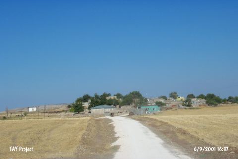
| Location: This site lies northwest of the city of Diyarbakir; 6 km south of the town of Ergani in the village of Yayvantepe (which used to be called Til Huzur). The survey code of the site is R 56 / 1. |
| Geography and Environment: The mound; which lies in the Ergani Plain; is east of the stream which feeds this plain; the Bogazçay. The mound is surrounded by the modern village of Yayvantepe. Modern abandoned buildings continue to add to the depositional mound process. The mound is now 9 m high and has a 150x100 m base [Benedict 1980:128]. The Yayvantepe villagers have damaged the northern part of the mound for soil for mud brick construction. There are two springs close to the site; one in the north and one in the northwest. |
| Destruction Details: The mound is destructed by contemporary settlement. The excavated area is being used as waste pit and there are houses all over the mound [TAYEx 6.9.2001]. |