|
©The Archaeological Settlements of Turkey - TAY Project
|
|
|
|
|
|
Müslümantepe |
|
|
For site maps and drawings please click on the picture...  |
For photographs please click on the photo... 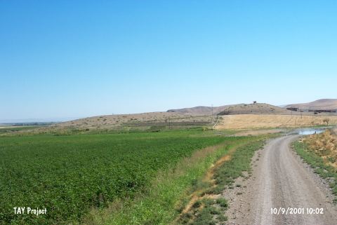 |
|
Type:
|
Mound |
|
Altitude:
|
480 m |
|
Region:
|
Southeastern Anatolia |
|
Province:
|
Diyarbakir |
|
District:
|
Bismil |
|
Village:
|
Sahintepe |
|
Investigation Method:
|
Excavation |
|
Period:
|
|
|
|
|
 |
|
| Location: The site is located to the north of Sahintepe (Till Sahn) village in the district of Bismil in Diyarbakir province. |
| Geography and Environment: The mound is on a promontory projecting into the valley floor on the south bank of Tigris; separated from the mainland by a natural rocky outcrop with the appearance of a peninsula extending into the valley to its south. To the north and west it is bounded by Tigris; and to the east by Çölemezri Dere; which flows from the south and empties into Tigris after skirting the mound. The modern village begins from the southeastern slope of the hill. |
| History: |
| Research and Excavation: Müslümantepe was first visited by G. Algaze and his team during their survey of the Upper Tigris Valley. It was surveyed in 1999 by E. Ay from the University of Kirikkale; Faculty of Science; History Department and his team. The excavation was conducted in 2000 by a team under the direction of E. Ay with the financial support provided by METU-TAÇDAM. The excavations were taken over by the General Directorate of Cultural Heritage and Museums of Turkey in 2005. The studies are carried out in three areas: Müslümantepe, Hõristiyantepe and the graveyard [Ay et al. 2013:273]. The trenches named S, T, U, V, and Y are located in Müslümantepe; the trenches named DD, EE, FF, GG, HH, JJ, KK, LL, MM, NN, OO, and PP are in Hõristiyantepe and the trenches named C, D, E, F and G are in the graveyard. It takes place in the registered archaeological sites list prepared by Ministry of Culture and Tourism. |
| Stratigraphy: On the summit of the mound; a step trench was opened extending from the highest point towards the north. Immediately beneath the topsoil; a large number of Medieval burials were encountered. The Islamic burials in the same are were also cut into the stone foundations of level I; and a large amount of Neo-Assyrian Period pottery was uncovered from the sediment. On the northeastern skirts of the mount; architectural remains were encountered immediately beneath the surface [Ay 2002a:508-509]. Apart from the cone of the mound that is preserved up to date, the settlement covers an area of 20 hectares. However, the northern section of the mound was entirely damaged due to soil removal and floods. During the studies conducted in the field near Tigris River, about 60 m north of the cone of the mound, a cultural layer of about 2 m thick was revealed. The human remains found during the agricultural activities in the surrounding area show that the 2nd millennium BC and Late IA Müslümantepe spread over a large area. It is believed that the layers belonging to Late IA and later periods remained under the modern village settlement. The foundation excavations and sounding studies also support this argument [Ay et al. 2013:274]. In Hõristiyantepe, a stepped trench was opened in the northwest corner of the mound in order to understand the stratigraphic development in 2005. The potsherds dated to Ubaid Period were found in Trench DD 11 [Ay et al. 2013:277-8]. |
| Small Finds: Architecture: On the summit of the mound; beneath the late period burials; an open area and a building with rubble-built ground floor and stone foundations were found. The building is a rectangular room in east-west orientation and its entrance is at the north end of the west wall. Directly opposite the entrance; an oven was found leaning against the north wall. During the excavations carried out on the west slope of the mound; a 1.5 m thick mudbrick wall with an east-west orientation was encountered. This wall was abutted by five narrow walls extending fan-like towards the south. These narrow walls; which were not neatly constructed; have the appearance of screen partitions of an open area rather than walls that support the ceiling. On the floor of this area; were exposed an oven and a pit which had a special kind of clay floor for heat insulation and a multi-compacted plaster lining. According to the metal slags and fragments of crucibles; it is suggested that this area was used as a kind of rolling mill. To the east of these rooms; a pebble paved street was uncovered. Pieces of pottery and animal bones were also used to form the paving. In the southern section of the settlement; two rooms were uncovered; both in an east-west orientation; one in an oval plan; the other rectangular. Their walls were constructed from mudbrick from the floor level. The oval room is about 1 m in diameter and according to the traces of black clay found on its floor; it is suggested that this room must have been a sanding workshop. In the rectangular room; were found an in situ pithos base and scattered fragments of other pithoi. To the south of these two rooms; there is a garbage pit containing a large quantity of ash [Ay 2002a:508-511]. The Chalcolithic level revealed in the trenches of JJ and KK 18-19 in Hõristiyantepe was damaged by the EBA structures. During the studies conducted in the trenches of C 79, E/F 85-87 in the graveyard in 2015, remains of walls were exposed. Traces of double-row foundations built with pebble stone can be followed. This structure is cut by a cist grave dated to the 3rd millennium BC. In the trenches of E/F 84-85, a quadrangular planned room and a hearth at the center of it were exposed. There is a pebble-paved area that could be a courtyard or a street just in the north [Ay et al. 2013:278]. The 2006-2007 studies conducted in the graveyard in Trench E82 yielded a grill planned, northeast-southwest oriented structure that has a 4-row stone foundation. In the trenches of F80-81, a grill-planned structure with pise walls was exposed. This structure continues towards the Trench G80-81 and is at the same direction with the grill-planned structure [Ay et al. 2013:278-9]. Pottery: To the south of the mound; was found a well-preserved metallic ware miniature jar; which probably was a burial gift. The jar has an incurving convex and vertical everted direct rim; a narrow mouth and a short neck. Close parallels of this ovoid bodied; thick walled and rounded based jar were known from the Ur Dynasty levels of Girnavaz [Ay 2002a:512]. In Trench E 87, a spouted jug in Late Chalcolithic-EBA characteristics was found in situ inside a wall. There are also red burnished Late Uruk footed bowls left as grave goods [Ay et al. 2013:278-9]. Ground Stone: Grindstones and crucible fragments were found. Clay: From the rooms on the skirt of the settlement were found loom weights; spindle whorls and heads of wool spindles. Two baked clay finials, symmetrically standing, were found. The pedestals are intact but the ends are broken. It seems like the ends are in the crescent shape (the symbol of Sin/Moon God) [Ay et al. 2013:279]. Metal: Metal slags; flat bronze rods and sewing needles were encountered. Other: Inside the miniature jar; two figurines made from quartz were found; one is a ram ant the other a fox or wolf. During the 2008 excavations, cylindrical seals with geometric patterns in the Late Uruk-Jemdet Nasr style were found [Ay et al. 2013:278-9]. |
| Remains: |
| Interpretation and Dating: It is suggested that Müslümantepe was used continuously from the Chalcolithic through the Roman Period and it is believed that with further investigations; the site will have an important role for the studies of Neo-Assyrian; Ur Dynasty and Late Uruk periods of the Upper Tigris cultural region [Ay 2002b:415]. The flood in 2007 led to the formation of a spring in the Çoramezri streambed. This event made it clear that why the graveyard and 4th millennium BC settlement founded in this area [Ay et al. 2013:274]. |