| ©The Archaeological Settlements of Turkey - TAY Project | ||||||
|
|
||||||
Müslümantepe |
||||||
|
|
||||||
| Ages | Maps | Photos | ||||
| Chalcolithic EBA IA |
 |
 |
||||
|
|
||||||
|
Type:
|
Mound | |||||
|
Altitude:
|
480 m | |||||
|
Diameter:
|
m- Direction: | |||||
|
|
||||||
|
Region:
|
Southeastern Anatolia | |||||
|
Province:
|
Diyarbakir | |||||
|
District:
|
Bismil | |||||
|
Village:
|
Sahintepe | |||||
|
|
||||||
|
|
||||||
|
|
||||||
|
TAYEx:
|
Visited - 10/9/2001 | |||||
|
|
||||||
|
Registration State:
|
Registered For detailed registration information please refer to Turkish pages. | |||||
 |
||||||
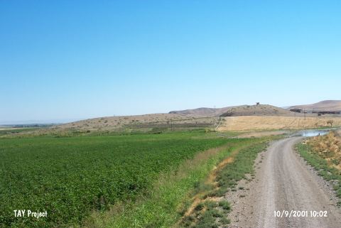
| Location: The site is located to the north of Sahintepe (Till Sahn) village in the district of Bismil in Diyarbakir province. |
| Geography and Environment: The mound is on a promontory projecting into the valley floor on the south bank of Tigris; separated from the mainland by a natural rocky outcrop with the appearance of a peninsula extending into the valley to its south. To the north and west it is bounded by Tigris; and to the east by Çölemezri Dere; which flows from the south and empties into Tigris after skirting the mound. The modern village begins from the southeastern slope of the hill. |
| Destruction Details: The northern section of the mound was entirely damaged due to soil removal and floods. |