|
©The Archaeological Settlements of Turkey - TAY Project
|
|
|
|
|
|
Biris Mezarligi |
|
|
For site maps and drawings please click on the picture...  |
For photographs please click on the photo... 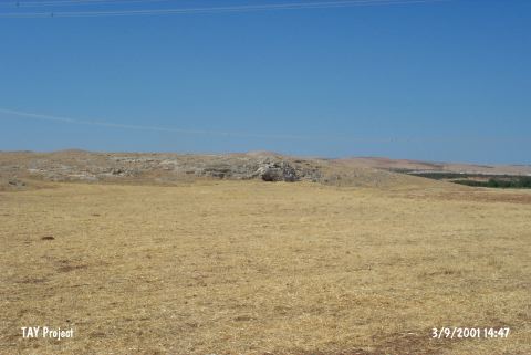 |
|
Type:
|
Artifact Scatter |
|
Altitude:
|
580 m |
|
Region:
|
Southeastern Anatolia |
|
Province:
|
Sanliurfa |
|
District:
|
Bozova |
|
Village:
|
Merkez |
|
Investigation Method:
|
Excavation |
|
Period:
|
ÜP |
|
|
|
 |
|
| Location: This site is located southwest of the site of Sanliurfa; approximately 2 km south of the town of Bozova; in the Küçük Gölbasi Region; and on the rocky plain west of an artificial lake/water reservoir. The site lies 4.5 km northwest of the village of Biris. The survey code of this site is U 51 / 1. |
| Geography and Environment: The mound on the rocky slope is 120x25 m in size and is currently used as the graveyard for the village of Biris; especially on the upper and eastern sides. One of the names of the site; Biris Mezarligi; literally means "the Biris graveyard". The site has also been referred to as Küçük Gölbasi. The graves have damaged part of the campsite/habitation area. Perhaps the most important reason in prehistory for selecting this site is because it is close to the spring; which is the current source of water which feeds the water reservoir (For further information see Harmankaya-Tanindi 1996:Biris Mezarligi). |
| History: |
| Research and Excavation: A southeast Anatolian survey jointly conducted in 1963 by the University of Istanbul; Faculty of Letters; Prehistory Section and the University of Chicago; Oriental Institute. discovered this site and the site of Sögüt Tarlasi Höyük immediately north of it [Benedict 1980:136]. An excavation was conducted the following year because of the uniqueness of the artifacts. A 5x8 m and a 2x3 m trench were opened at the site; exposing a 46 square-meter area. While the larger trench was opened far from the lake; on the western side of the mound; the smaller one was immediately southwest of the lake. The red depositional fill; which yielded artifacts; is between 30-40 m in depth; although this depth varies where there were depressions in the virgin soil. Because the cultural deposit is extremely thin and so close to the surface; the site has been destroyed by the modern graves. The modern graves damaged the site so badly that the excavations could not provide characteristic artifacts to define the site. |
| Stratigraphy: |
| Small Finds: Along with numerous well-made flint tools such as burins and scrapers; Howe also mentions that the site yielded examples of a microlith blade industry. The artifacts are very similar to the finds from the nearby site of Sögüt Tarlasi Höyük. The chipped stone tool industry of this site is currently being prepared for publication by Howe. |
| Remains: |
| Interpretation and Dating: |