|
©The Archaeological Settlements of Turkey - TAY Project
|
|
|
|
|
|
Biris Mezarligi |
|
|
For site maps and drawings please click on the picture...  |
For photographs please click on the photo... 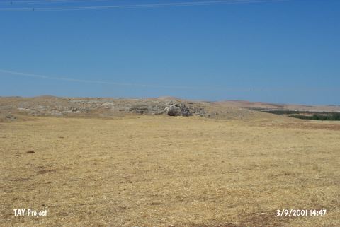 |
|
Type:
|
Artifact Scatter |
|
Altitude:
|
580 m |
|
Region:
|
Southeastern Anatolia |
|
Province:
|
Sanliurfa |
|
District:
|
Bozova |
|
Village:
|
Merkez |
|
Investigation Method:
|
Excavation |
|
Period:
|
Aceramic |
|
|
|
 |
|
| Location: This site is located southwest of the site of Sanliurfa; approximately 2 km south of the town of Bozova; in the Küçük Gölbasi Region; and on the rocky plain west of an artificial lake/water reservoir. The site lies 4.5 km northwest of the village of Biris. The survey code of this site is U 51 / 1. |
| Geography and Environment: The mound on the rocky slope is 120x25 m in size and is currently used as the graveyard for the village of Biris; especially on the upper and eastern sides. One of the names of the site; Biris Mezarligi; literally means "the Biris graveyard". The site has also been referred to as Küçük Gölbasi. The graves have damaged part of the campsite/habitation area. Perhaps the most important reason in prehistory for selecting this site is because it is close to the spring; which is the current source of water which feeds the water reservoir (For further information see Harmankaya-Tanindi 1996:Biris Mezarligi). |
| History: |
| Research and Excavation: A southeast Anatolian survey jointly conducted in 1963 by the University of Istanbul; Faculty of Letters; Prehistory Section and the University of Chicago; Oriental Institute. discovered this site and the site of Sögüt Tarlasi Höyük immediately north of it [Benedict 1980:136]. An excavation was conducted the following year because of the uniqueness of the artifacts. A 5x8 m and a 2x3 m trench were opened at the site; exposing a 46 square-meter area. While the larger trench was opened far from the lake; on the western side of the mound; the smaller one was immediately southwest of the lake. The red depositional fill; which yielded artifacts; is between 30-40 m in depth; although this depth varies where there were depressions in the virgin soil. Because the cultural deposit is extremely thin and so close to the surface; the site has been destroyed by the modern graves. The modern graves damaged the site so badly that the excavations could not provide characteristic artifacts to define the site. |
| Stratigraphy: |
| Small Finds: Chipped Stone: It is reported that the finds from this site are quite different from the Neolithic site of Çayönü in Diyarbakir [Çambel-Braidwood 1980:13]. The chipped stone assemblage at this site is comprised of good quality light to dark brown flint burins; scrapers and geometric micro-tools. A very small amount of obsidian was also recovered. |
| Remains: |
| Interpretation and Dating: The site; which appears to include Upper Palaeolithic characteristics; was previously placed in the transitional phase between the Epipalaeolithic and the Neolithic. In ASPRO; the site has been assigned to the Aceramic Neolithic; PPNB; due to some of the typological characteristics. Uncalibrated dates; which have been placed in the third and fourth phases; in ASPRO read 9;600-8;000 BP [Hours et al. 1994:83]. The claims made in TAY 1 [Harmankaya-Tanindi 1996:Biris Mezarligi] about a possible Aceramic Neolithic settlement at this site have been acknowledged in TAY 2; although a more definite interpretation of the data cannot be made before the analyzed material is published by Howe. |