|
©The Archaeological Settlements of Turkey - TAY Project
|
|
|
|
|
|
Akarçay Tepe |
|
|
For site maps and drawings please click on the picture...  |
For photographs please click on the photo... 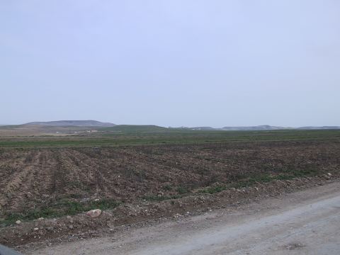 |
|
Type:
|
Mound |
|
Altitude:
|
355 m |
|
Region:
|
Southeastern Anatolia |
|
Province:
|
Sanliurfa |
|
District:
|
Birecik |
|
Village:
|
Akarçay |
|
Investigation Method:
|
Excavation |
|
Period:
|
|
|
|
|
 |
|
| It is located partially in the west and partially below the Akarçay Village, south of Birecik District southwest of Sanliurfa. Being a lengthy mound, it measures 350 m long in the east-west direction, and 150 m long in the north-south direction. It has a size of 12.97 acres (5.25 hectares) and approximate height of 2 m. It lies on the alluvial area separated by the Su Stream. It has been partly obscured by the Akarçay Village. The Aceramic Neolithic, Ceramic Neolithic, Late Ubaid, Late Chalcolithic and Iron Ages were identified in the settlement. The mound covered an area of 1.24 acres during the Iron Age. The outer part of the settlement will be flooded by the dam [Algaze et al. 1994:56]. |
| Location: This site lies west of the city of Sanliurfa; south of the town of Birecik and west and partially under the village of Akarçay. The Elementary School of the village is partially built over the mound. |
| Geography and Environment: The Akarçaytepe mound-site is located south of Su Stream which is a small a tributary of the Euphrates and it lies on alluvial deposits. The dimensions of the mound; which consists of two small hills; are 150 m north-south and 350 m east-west. The mound is only 2 m high. There are nearby water-sources. There are also some flint resources and limestone formations that provide raw materials for the Neolithic Period settlement. |
| History: |
| Research and Excavation: |
| Stratigraphy: |
| Small Finds: |
| Remains: |
| Interpretation and Dating: |