| ©The Archaeological Settlements of Turkey - TAY Project | ||||||
|
|
||||||
Akarçay Tepe |
||||||
|
|
||||||
| Ages | Maps | Photos | ||||
| Neolithic Chalcolithic IA 14C |
 |
 |
||||
|
|
||||||
|
Type:
|
Mound | |||||
|
Altitude:
|
355 m | |||||
|
Diameter:
|
m- Direction: | |||||
|
|
||||||
|
Region:
|
Southeastern Anatolia | |||||
|
Province:
|
Sanliurfa | |||||
|
District:
|
Birecik | |||||
|
Village:
|
Akarçay | |||||
|
|
||||||
|
|
||||||
|
|
||||||
|
TAYEx:
|
Not visited - 2/9/2001 | |||||
|
|
||||||
|
Registration State:
|
Registered For detailed registration information please refer to Turkish pages. | |||||
 |
||||||
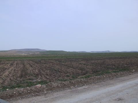
| Location: This site lies west of the city of Sanliurfa; south of the town of Birecik and west and partially under the village of Akarçay. The Elementary School of the village is partially built over the mound. |
| Geography and Environment: The Akarçaytepe mound-site is located south of Su Stream which is a small a tributary of the Euphrates and it lies on alluvial deposits. The dimensions of the mound; which consists of two small hills; are 150 m north-south and 350 m east-west. The mound is only 2 m high. There are nearby water-sources. There are also some flint resources and limestone formations that provide raw materials for the Neolithic Period settlement. |
| Destruction Details: |