|
©The Archaeological Settlements of Turkey - TAY Project
|
|
|
|
|
|
Ikiztepe |
|
|
For site maps and drawings please click on the picture...  |
For photographs please click on the photo... 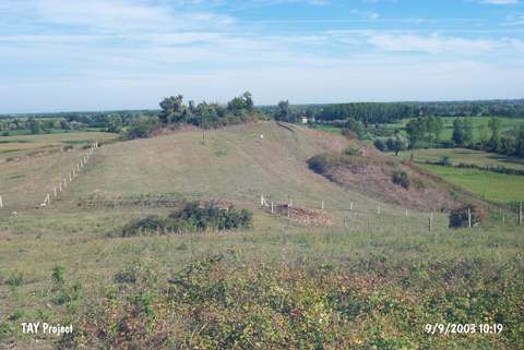 |
|
Type:
|
Mound |
|
Altitude:
|
115 m |
|
Region:
|
Black Sea |
|
Province:
|
Samsun |
|
District:
|
Bafra |
|
Village:
|
Ikiztepe |
|
Investigation Method:
|
Excavation |
|
Period:
|
|
|
|
|
 |
|
| Location: It is located immediate north of the Ikiztepe Village; 7 km northwest of Bafra; about 55 km of Samsun. |
| Geography and Environment: The mound is situated near a location where the Kizilirmak River empties into the Black Sea; on the western bank of the river. When observed from a far location it looks as though there were two small hills; therefore it was named Ikiztepe; which suggests Twin Hills in Turkish; actually the mound consists of two large and two small hills. The hills were numbered in Roman numerals by the excavation leaders. The largest one of the hills in the south was called Hill I. Hill I is 29 m from the plain. The second hill in the north of this one is round shaped (Hill II); and it is 22.5 m from the plain. The farthest north Hill III; of all four hills is smaller than the first two in terms of height and size. The height of this hill is 12.3 m. The Hill IV in thewest of Hill II is almost 16 m in height. The size of the settlement consisting of those four hills and the area in between measures 175x375 m. The geological researches proves that the settlement which is 7 km from the sea shore at present was in fact very close to the shore during 5-3 Millenium BC; and during that period Kizilirmak reached the sea shore near the settlement. As a result of the researches it may be stated that the communities in the region were active in the sea. |
| History: |
| Research and Excavation: Discovered in 1941 by K. Kökten, T. and N. Özgü, Ikiztepe was also visited by C.A. Burney [Burney 1956:181-183, 189]. Later on, it was eavulated by W. Orthmann and J. A. Dengate [Dengate 1971:199]. The surface finds were reevaluated by B. Alkim during the Survey of the Samsun Region (1971-74), a plan of the hill was outlined, and excavations were initiated from 1974 based on the assumption that it may be identified with the city of Zalpa as it provided finds dating to the Early-Hittite Period (early 2nd Millennium: Transition Period). Being excavated until 1980 by B. Alkim, the excavations have been conducted under the direction of Ö. Bilgi since 1981. It is listed among the registered archaeological sites prepared by the Ministry of Culture and Tourism. |
| Stratigraphy: Being excavated relatively for a very long period time among other prehistoric sites in Anatolia, the following stratification of Ikiztepe is based on the excavations conducted on the hilltops and the neck between the hills until the end of 1999 campaign: Hill I Hill I to II Hill II Hill III Tepe IV Transition period: I (Layers 1-6) I (Layers 1-2) I (Layers 1-2) I EBA III: Cemetery II (Layers 1-2) II (Layers 1-4) Virgin soil EBA II: Ia-b III (Layers 1-10) I (Layers 1-2) III (5-19.kat) EBA I: II (Layers 1-5) IV (Layers 1-5) II (Layers 3-8) LCA: Late Chalcolithic III (1-8.kat) Virgin soil Virgin soil |
| Small Finds: Architecture: The excavations on Hill III yielded an open air kiln and two burials. The large pithos fragments found in situ in the kiln suggest that the kiln was from the Late Iron Age [Bilgi 1995: res. 5; Bilgi 1999: pics. 9, 11]. Pottery: Among the sherds collected from the surface during the 1993 campaign on the Hill III are samples from the Hellenistic and Hittite Periods and Late Iron Age [Bilgi 1995:res. 26, Bilgi 1999: 27, drw. 5-8, 13]. The motifs on the painted sherds from the Iron Age indicate that they belong to the group of ware known as Phrygian ceramics in the Central Anatolia. Similar material were recovered from the Akalan settlement near Samsun, and dated to the Late Iron Age [Cummer 1976:31-39]. In addition to the painted ware, a wheel-made monochrome sherd in grey was also found [Bilgi 1999:31, pic.12]. Such material indicate the presence of Late Iron Age settlements, which were contemporary to the Hellenistic Period, and have been destroyed due to erosion and agricultural activities. Human Remains: In the graves exposed near the western edge of the area, the skeletons were found being placed on their back in opposite directions. The right arms lay straight next to the body while the other arms were slightly bended with the hands placed on the pelvis [Bilgi 1995: pic. 6, drw. 4; Bilgi 1999: drws.10, 11]. This burial tradition unusual in the region suggests that they may have belonged to the Late Iron Age as they were on the upper layers. |
| Remains: |
| Interpretation and Dating: |