| ©The Archaeological Settlements of Turkey - TAY Project | ||||||
|
|
||||||
Ikiztepe |
||||||
|
|
||||||
| Ages | Maps | Photos | ||||
| Chalcolithic EBA IA 14C |
 |
 |
||||
|
|
||||||
|
Type:
|
Mound | |||||
|
Altitude:
|
115 m | |||||
|
Diameter:
|
m- Direction: | |||||
|
|
||||||
|
Region:
|
Black Sea | |||||
|
Province:
|
Samsun | |||||
|
District:
|
Bafra | |||||
|
Village:
|
Ikiztepe | |||||
|
|
||||||
|
|
||||||
|
|
||||||
|
TAYEx:
|
Visited - 9/9/2003 | |||||
|
|
||||||
|
Registration State:
|
Registered For detailed registration information please refer to Turkish pages. | |||||
 |
||||||
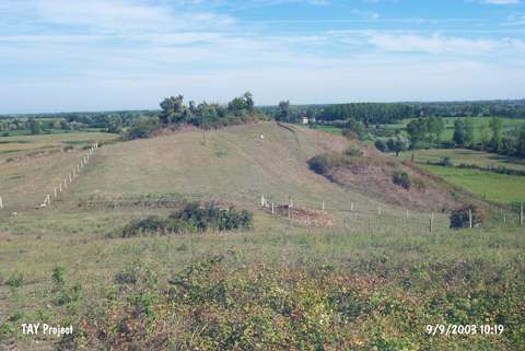
| Location: It is located immediate north of the Ikiztepe Village; 7 km northwest of Bafra; about 55 km of Samsun. |
| Geography and Environment: The mound is situated near a location where the Kizilirmak River empties into the Black Sea; on the western bank of the river. When observed from a far location it looks as though there were two small hills; therefore it was named Ikiztepe; which suggests Twin Hills in Turkish; actually the mound consists of two large and two small hills. The hills were numbered in Roman numerals by the excavation leaders. The largest one of the hills in the south was called Hill I. Hill I is 29 m from the plain. The second hill in the north of this one is round shaped (Hill II); and it is 22.5 m from the plain. The farthest north Hill III; of all four hills is smaller than the first two in terms of height and size. The height of this hill is 12.3 m. The Hill IV in thewest of Hill II is almost 16 m in height. The size of the settlement consisting of those four hills and the area in between measures 175x375 m. The geological researches proves that the settlement which is 7 km from the sea shore at present was in fact very close to the shore during 5-3 Millenium BC; and during that period Kizilirmak reached the sea shore near the settlement. As a result of the researches it may be stated that the communities in the region were active in the sea. |
| Destruction Details: |