|
©The Archaeological Settlements of Turkey - TAY Project
|
|
|
|
|
|
Kaledorugu / Kavak |
|
|
For site maps and drawings please click on the picture...  |
For photographs please click on the photo... 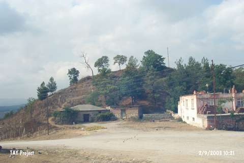 |
|
Type:
|
Mound |
|
Altitude:
|
685 m |
|
Region:
|
Black Sea |
|
Province:
|
Samsun |
|
District:
|
Kavak |
|
Village:
|
Merkez |
|
Investigation Method:
|
Excavation |
|
Period:
|
Late Iron Age |
|
|
|
 |
|
| It is situated within the Yeni Cami Quarter of the Kavak District, approximately 40 km south of the provincial center of Samsun. In some publications it is mistakenly introduced as Kavak instead of Kaledorugu. It is accessed through the Samsun-Kavak motorway. It was first presented to the world of archaeology by von der Osten, followed by excavations conducted between 1940 and 1941 by I.K. Kökten, N. Özgüç and T. Özgüç. Four cultural levels including EBA, MBA, Hellenistic and Roman Periods were identified in addition to Medieval Age. Sherds dating to the Late Iron Age were found during the surveys under the direction of U.B. Alkim. It takes place in the registered archaeological sites list prepared by Ministry of Culture and Tourism. |
| Location: It is located in Yeni Cami Quarter of Kavak District; some 40 km south of the Samsun Province. It is mistakenly introduced as Kavak in some publications. It can be easily reached through the Samsun-Kavak motorway. |
| Geography and Environment: It is an oval hill with steep slopes. It measures 25 m in height and 350x250 m in dimensions. It stands on a rocky block surfacing on the southern and eastern parts. The Aglidere Stream flows next to the mound. It overlooks the Kavak Plain on the south. It is located on a natural road reaching to Havza; Amasya from Samsun. It has been destroyed due to illicit diggings. The top hill has been flattened. Remains of a fortress are observed on the surface. |
| History: |
| Research and Excavation: |
| Stratigraphy: |
| Small Finds: |
| Remains: |
| Interpretation and Dating: |