|
©The Archaeological Settlements of Turkey - TAY Project
|
|
|
|
|
|
Norsuntepe |
|
|
For site maps and drawings please click on the picture...  |
For photographs please click on the photo... 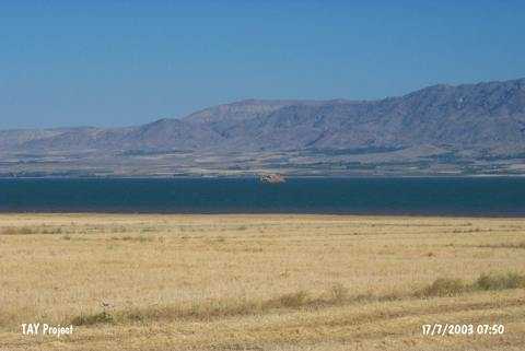 |
|
Type:
|
Mound |
|
Altitude:
|
885 m |
|
Region:
|
Eastern Anatolia |
|
Province:
|
Elazig |
|
District:
|
Merkez |
|
Village:
|
Alisam |
|
Investigation Method:
|
Excavation |
|
Period:
|
Early Iron Age Middle Iron Age |
|
|
|
 |
|
| Location: The site is located 26 km southeast of Elazig; within the geographical triangle of the villages of Alisam (Harmanpinari); Yukari Aginsi (Elmapinar); and Asagi Aginsi (Kavakalti). It is 3 km south of the village of Alisam. The mound has become an island in the reservoir of Keban Dam after 1975 and now is vanishing slowly. The name is local and the location code is O 54 / 8. |
| Geography and Environment: The conical; 150x130 m mound with a height of 35 m used to be one of the larger mounds of Altinova Region. It used to cover an area of 500x300 m together with its slopes. The region is a watery and fertile plain; framed by Mastar and Bingöl Mountains and irrigated by Heringet Stream and Karasu River. Today; this plain is mostly inundated; as well. |
| History: |
| Research and Excavation: Attracting the attention of scientists conducting surveys on the plain (Kökten, Meriggi) and the travelers going from Elazig to Bitlis as it could be easily seen from the motorway, the mound was investigated in 1967 in detail by R. Whallon Jr. and S. Kantman who were surveying the area that would be flooded by the Keban Dam [Whallon-Kantman 1970:2]. The excavation which was started in 1968 under the direction of H. Hauptmann in the name of the German Archaeological Institute was ceased in 1974 when the hill partly submerged. The excavation was conducted in four sections; acropolis, southern terrace, western slope and fields in parallel to its size. The Early Iron Age levels and settlement area are prominent. The Middle Iron Age structures are concentrated on the southern section of the mound. They mainly reflect their architectural characteristics. |
| Stratigraphy: It was revealed that Norsuntepe had been intensely occupied from the Late Chalcolithic Age until the end of the Iron Age. The stratigraphy of the mound is as follows: Building level 1: Middle Iron Age (Urartian Period 8th century BC) Building level 2: Early Iron Age Building levels 3-5: 2nd Millennium BC Building levels 6-8: Early Bronze Age III phase C Building levels 9-10: Early Bronze Age III phase B Building levels 11-12: Early Bronze Age III phase A Building levels 13-20: Early Bronze Age II phase B Building levels 21-24: Early Bronze Age II phase A Building levels 25-30: Early Bronze Age I phase B Gap: Early Bronze Age I phase A Building levels 31-40: Late Chalcolithic Age |
| Small Finds: Architecture: The Early Iron Age settlement on the northern section of the south terrace has no planning, being represented mostly like a village settlement with different groups of domestic structures. The excavations yielded a building complex dating to the Early Iron Age on the southern section of the mound. An Iron Age layer with four phases was exposed at Norsuntepe. Founded over a burnt layer of the Late Bronze Age, the Early Iron Age layer consists of a village of fortified houses and quarters. The houses composed of a few rooms have stone foundations and mudbrick walls supported by wooden beams. The fortifications composed of a row of large stone blocks between the terrace and the hill, strecthing from southwest to northeast are from the first phase. In the second phase, remains of several intercommunicating structures, obviously part of a common architectural complex and fortification walls were uncovered. With an approximate height of 0,60 m, the fortification walls were dressed at some sections. The surface of walls made of quarry stones with an approximate width of two mudbricks was inelaborately plastered. The mudbrick debris and burnt beam fragments indicate presence of upper floors, which seem to have projected out above the first floor. A three-roomed house with a dimension of 8x8.50 m from the third phase yielded ruins of ovens with a beehive shape and decorated cooking rims. Size of the house and distribution of rooms indicate that it was a common living area. The smaller rooms with a dimension of 2x3 and 2x2 m are connected to a common room to the north through a corridor. The occupation area of Norsuntepe during the Early Iron Age is composed of many groups of houses arranged adjacent to each other. Traces of fire are observed in each of the architectural units. Pottery: The pottery of Norsuntepe provides significant data in terms of chronology and typology of the Early Iron Age ceramics as they belong to a certain Early Iron Age layer. With a homogeneous structure, the pottery can be analyzed in four groups, including round and sharp shouldered bowls with grooves under the rim, spouted and lugged pots, vase- and jug-like vessels, and paint and incision decorated vessels. The vessels are mainly handmade and well-cooked, and they usually have a coarse appearance with a thick wall. The surface colors range from beige and light brown to light tile red. The trenches R22c and R23a yielded seven graves dating to the Middle Iron Age immediately under the ground. They included burial gifts. The skeleton 1 in R 22c is northwest oriented, lying on its back with the head facing east. The burial gifts include iron arrowheads and blade. Similars of the tanged blade with a curved back and the wide crested and tanged arrowhead are found in the Urartian excavation sites. To the immediate west of this grave is the grave 2 on the same level. Near the head of the skeleton are two trefoil jugs, almost intact, made of a light colored paste. Ring-footed jug with a prominent ventral profile, and a circle band around the neck and a flat handle reflects a dominant style of the Urartian pottery. The smaller jug bears several dots made by impression at where the handle combines with the body and interpreted as signs defining some figures. In the northern section of a pit a third grave was found, including a child's skeleton in hocker position. The architectural remains from the Middle Iron Age were uncovered in the southern section of O 22/23 and P 23. The large stone pavement of 3,20x3,60 m uncovered in P/Q 23 may have been related with the large pit and the room inside it. The trapezoidal small room with lateral lenghts of 3 to 2.8 or 2 m in O 22 a/c was uncovered. The excavations on the southern terrace of the hill yielded sherds from the Middle Iron Age. Small Finds: Among the small finds of Norsuntepe are beads with eye decorations, a few figurine heads made of clay, a blade with a rectangular tang made of iron, glass beads and a Late Hittite hieroglyphic seal impression. |
| Remains: |
| Interpretation and Dating: Norsuntepe is an easily accessed and investigated site by the archaeologists and travellers as it is located on the Elasig-Bingöl motorway. The mound had been occupied from the Chalcolithic Age until the Middle Iron Age. Being occupied for a long period of time, the excavations of this site brought new information for the scientific world. There is a two-phase occupation during the Iron Age: Early Iron Age and Middle Iron Age. Norsuntepe is the site of a certain Early Iron Age settlement. Thus, it is significant in shedding light on the Early Iron Age with supply of data and architectural features. The data of the Middle Iron Age is represented by the finds from the seven graves uncovered. |