|
©The Archaeological Settlements of Turkey - TAY Project
|
|
|
|
|
|
Üçtepe / Kerh |
|
|
For site maps and drawings please click on the picture... 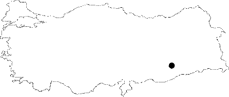 |
For photographs please click on the photo... 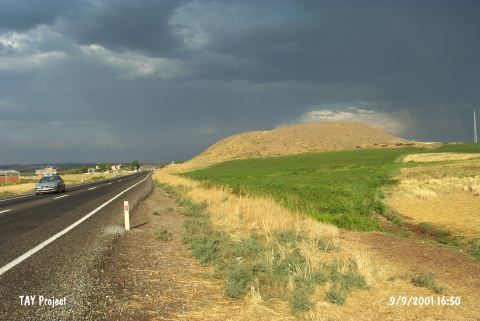 |
|
Type:
|
Mound |
|
Altitude:
|
614 m |
|
Region:
|
Southeastern Anatolia |
|
Province:
|
Diyarbakir |
|
District:
|
Bismil |
|
Village:
|
Üçtepe |
|
Investigation Method:
|
Excavation |
|
Period:
|
New Assyrian Empire Period Late Iron Age Late New Assyrian Period |
|
|
|
 |
|
| Location: It lies immediate west (200-300 m) of the former Kerh or Kerh-i Dicle Village recently named as Üçtepe located 10 km west-southwest of the Bismil District; 40 km southeast of the Diyarbakir Province [Sevin 1990:pic.2] |
| Geography and Environment: It is located on the western bank of the Göksu Stream; one of the branches of the Tigris. It stands on a conglomeratic hill. It measures 44 m in height and 200x180 m in dimensions [Sevin 1990:103-104]. Overlooking the valley of Göksu; it looks like an oval hill inclining from south to north. |
| History: |
| Research and Excavation: The British consul, J.C. Taylor found two steles which belong to Assurnasirpal II and Salmanasar III in the settlement area so called Kurkh in 1865 when he was in Diyarbakir. These steles are known as Kurkh Monoliths and they were published by G. Smith [Na'aman 1976:89]. Afterwards, A.T. Olmstead performed investigations at Üçtepe during the survey he conducted in the mounds on the bank of the Tigris River in 1907. Until 1986 except for a few surveys, all researches in the region came to a halt [Özfirat 2005a:3]. Excavations were initiated for defining the stratigraphy of Üçtepe as being one of the largest mounds in East and Southeast Anatolia, and considering that it can be identified with the ancient city of Tushpa or Tushpan in order to determine the location of the provincial palace founded by the Assyrian King Assurnasirpal I during the first quarter of the 9th century BC. In 1988 the excavations started under the direction of V. Sevin were performed in four trenches; two in the northern, and two in the eastern slopes [Sevin 1993:175-176]. Excavations lasted until 1992 [Özfırat 2005a:4]. It lies north-northwest of Üçhöyük Village; northwest of Altintas District; south of Kütahya Province. |
| Stratigraphy: Based on the prehistorical material which was reflected very weakly on the surface due to the large coverage by the Iron Age and Hellenistic&Roman Period levels, the site had been inhabited from the Halafian Period into the Early Bronze Age. However, the mound gets its fame from the two Assyrian limestone steles found in 1865 by J.G. Taylor [Sevin 1990:103-104]. The excavations in 1992 yielded a stratigraphy that extends from the Middle Iron Age to the Middle Bronze Age in the east trenches. Based on the excavations in the trenches III, X and XII, the following levels were identified from top to bottom: - Roman Period (building levels 1-4.) - Hellenistic Period (building levels 5-6) - Neo-Assyrian Period (building levels 7-8) - Middle Assyrian Period (building level 9) - Middle Bronze-Late Bronze Age (building level 10) - Middle Bronze Age/Colonization Period (building level 11) - Early Bronze Age, final phase (building levels 12 A-B-13) [Köroglu 2002:451; Özfirat 2005b:54-55]. The stepped trench to the southeast of the mound yielded Neo-Assyrian building levels, underlying the fortress remains with stone walls from the Hellenistic Period [Gates 1994:261]. |
| Small Finds: Architecture: The campaigns between 1988 and 1991 yielded Iron Age building levels in the east trenches [Sevin 1994b:400]. The trench VII reached down to level from the Neo Assyrian Period in 1991. An adobe wall was found here from that period, probably belonging to an important building. It contains fragments of painted reliefs on mud plaster in white and black, which are familiar from buildings at capitals such as Nineve, Kalhu and Dursarrukin and provincial centers of Til Barsip and Hadatu [Sevin 1993:179]. Mudbrick walls belonging to the building level 8, i.e. the late phase of the Neo-Assyrian Period were found below the building level 7. Although these walls which were seated directly on the ground without any foundation, have been preserved up to a height of 0.60 m, their thickness could not be determined due to their vulnerable condition to erosion on the slope [Sevin 1994b:401]. The 200 m wide cone of the mound is completely covered with Neo-Assyrian buildings. The thick and long wall traceable for approximately 44.5 m long on the southwestern slope should have belonged to a fortification enclosing the citadel [Özfirat 2005b:55]. Pottery: Although the triangle ware dating to the Late Iron Agewere not accompanied with relevant architectural elements in the east trenches, they indicate presence of an Late Iron Age level. In the light of the data obtained from other trenches, the cobble course surrounding the mound are immediately underlied by Neo-Assyrian period levels. The Neo-Assyrian period ceramics are observed on all of the three building levels identified in the mound. Among them are spouted goblets. The north trench yielded Neo-Assyrian sherds [Sevin 1990:103-104]. Grave: An inhumation burial belonging to a woman and her daughter was found in the building level 9 of the Late Middle Assyrian/Early Neo-Assyrian period. The dead were buried as dressed up along with their jewelry [Özfirat 2005b:54]. The grave yielded golden jewels, faience beads, bronze bracelet, ring and good quality ceramics [Mellink 1990:139]. Sculpture/Relief: The two limestone steles known in the world of archaeology as Kurkh Monoliths found in Üçtepe by the British Consul, J.G.Taylor in 1865 were first transported to Bagdat, then to the British Museum. The steles belong to Ashurnasirpal II (883-859BC) and his son Shalmaneser III (858-824 BC). The name Üçtepe is reknown for a long period of time with these steles [Özfirat 2005a:3]. |
| Remains: |
| Interpretation and Dating: Üçtepe/Kerh contains building levels that can provide important information, particularly on the Neo-Assyrian period and culture. The name of the settlement during the Assyrian Period and the problems concerning the historical geography of the region are assumed to be resolved as a result of excavations [Sevin 1989:13]. |