|
©The Archaeological Settlements of Turkey - TAY Project
|
|
|
|
|
|
Yayvantepe / Til Huzur |
|
|
For site maps and drawings please click on the picture...  |
For photographs please click on the photo... 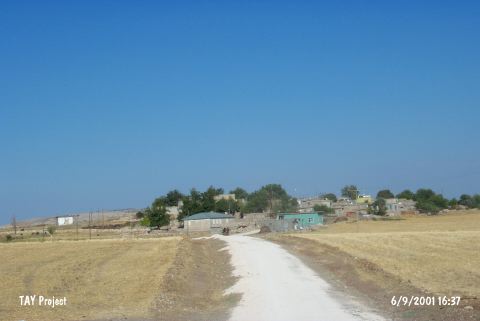 |
|
Type:
|
Mound |
|
Altitude:
|
810 m |
|
Region:
|
Southeastern Anatolia |
|
Province:
|
Diyarbakir |
|
District:
|
Ergani |
|
Village:
|
Yayvantepe |
|
Investigation Method:
|
Excavation |
|
Period:
|
|
|
|
|
 |
|
| It is situated in an alluvial plain to the south of Ergani. Based on the finds collected from the site, it was found that it had been inhabited during the Aceramic Neolithic, Chalcolithic, and Early Bronze Ages [Caneva 1993:107], and sherds with Iron Age characteristics were found. However, the site have been heavily destroyed [Caneva 1993:107-115]. It is also called Til Huzur. It takes place in the registered archaeological sites list prepared by Ministry of Culture and Tourism. |
| Location: This site lies northwest of the city of Diyarbakir; 6 km south of the town of Ergani in the village of Yayvantepe (which used to be called Til Huzur). The survey code of the site is R 56 / 1. |
| Geography and Environment: The mound; which lies in the Ergani Plain; is east of the stream which feeds this plain; the Bogazçay. The mound is surrounded by the modern village of Yayvantepe. Modern abandoned buildings continue to add to the depositional mound process. The mound is now 9 m high and has a 150x100 m base [Benedict 1980:128]. The Yayvantepe villagers have damaged the northern part of the mound for soil for mud brick construction. There are two springs close to the site; one in the north and one in the northwest. |
| History: |
| Research and Excavation: |
| Stratigraphy: |
| Small Finds: |
| Remains: |
| Interpretation and Dating: |