|
©The Archaeological Settlements of Turkey - TAY Project
|
|
|
|
|
|
Zeytinlibahçe Höyük |
|
|
For site maps and drawings please click on the picture...  |
For photographs please click on the photo... 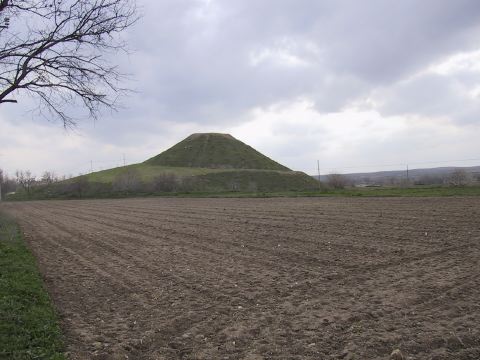 |
|
Type:
|
Mound |
|
Altitude:
|
490 m |
|
Region:
|
Southeastern Anatolia |
|
Province:
|
Sanliurfa |
|
District:
|
Birecik |
|
Village:
|
Mezraa |
|
Investigation Method:
|
Excavation |
|
Period:
|
|
|
|
|
 |
|
| Location: The mound lies west of Sanliurfa; 3 km south of Birecik; 1.4 km north of Mezraa village. |
| Geography and Environment: It is a conical and ovoid mound with an approximate height of 31 m [Deveci-Mergen 1999b:fig.2]. It measures 190 m in north-south; 140 m in east-west directions. The site covers an area of about 2.6 hectares and it is about 340 m above sea level. The site is located in the middle of fields and to the north of it there is a road running parallel to Euphrates. The foots of the settlement were cut for agriculture. |
| History: |
| Research and Excavation: It was discovered by G. Algaze, and surveyed by A. Deveci and Y. Mergen in 1998 [Mergen-Deveci 1999:98-99]. It was excavated under the direction of M. Frangipane in 1999 and 2000 within the scope of the Salvage Project of the Archaeological Heritage of the Ilisu and Carchemish Dam Reservoirs coordinated by METU-TAÇDAM [Frangipane-Bucak 2001:79]. It takes place in the registered archaeological sites list prepared by Ministry of Culture and Tourism. |
| Stratigraphy: The periods identified as a result of surveys and excavations are Halafian, Late Chalcolithic, EBA and Iron Age. In addition to these periods, presence of a settlement from the Parthian-Roman Period until the Middle Age is reported [Graves-Helwing 2001:480]. |
| Small Finds: Pottery: The excavations yielded no traces of any Iron Age building remains, but a limited number of Iron Age material on the surface on the western section. A loose soil deposit was revealed during the excavations in the north trench D2, including remains from the Byzantine Period, Middle Age and Iron Age at a depth of 2 m. One of the most important discoveries of the Zeytinlibahçe excavations during the 1999 campaign was a monumental structure. It is assumed that the Iron Age sherds collected from the surface may be used as a resource for dating this building. The pithoi fragments belonging to the Iron Age are similar to the examples found at Gritille and Lidar Höyük. The red slipped ware found during the comprehensive survey conducted on the mound in 1999 belongs to Iron Age. The red slip was applied on a beige surface and it has a mineral tempered paste, mainly used for production of large and mid-size vessels [Frangipane-Bucak 2001]. The entire deposit which has a depth of approximately 5 m underlying the Middle Age necropolis, and the Middle Age and Roman Period buildings uncovered in 1999 in section D2, contains a mixed archaeological assemblage. This material is dated in general to the Roman Period and after, however some Iron Age sherds were also found further below the deposit. Thus, it is suggested that there may be a secondary deposit here or a man-made soil deposit composed for construction of a terrace [Frangipane et al. 2002:41-42]. At the end of the 2000 campaign, some material dating to the Roman Period and Iron Age were uncovered in the Byzantine settlement [Frangipane et al. 2002:41-47]. The excavations in 2001 revealed that the Roman settlers collected debris in order to make an artificial terrace for expanding the settlement area, and this debris included some Iron Age material mixed with late period material, and there may be an Iron Age settlement near the mound [Frangipane et al. 2004:2]. Human Remains: Roman pits are unearthed along with an Iron Age burial during the excavations of 2002. In terms of Iron Age deposits, a baked sarcophagus is located in the centre (T1) and a large burial pit that is partially preserved is located in its South (T2). The sarcophagus is made of two pieces made and baked separately and decorated with finger imprinted cordons on the edges. Four bulges exist in the East of the sarcophagus both inside and outside. Under the sarcophagus the impressions of a mat can be seen clearly although very sporadic. The buried adult is a 1.90 - 1.92 m tall male and it seems like his knees are bent in order to fit in the sarcophagus. An iron knife is found within the sarcophagus between the right arm and the chest as well as a small amphora and a bowl used as a lid. And some animal bones are also captured. A long pot-amphora is left beside the head and outside the sarcophagus which is shut with a bowl, while intense bird bones are observed around the feet. Inside the pithos grave a small frit-made vessel is found decorated with geometrical reliefs. A bronze needle, a bone which was possibly part of a handle, and a small horn piece are found under the skull. This entire Iron Age complex is crossing the MBA structures [Frangipane et al. 2011: 3]. |
| Remains: |
| Interpretation and Dating: |