| ©The Archaeological Settlements of Turkey - TAY Project | ||||||
|
|
||||||
Höyücek |
||||||
|
|
||||||
| Ages | Maps | Photos | ||||
| Neolithic EBA 14C |
 |
 |
||||
|
|
||||||
|
Type:
|
Mound | |||||
|
Altitude:
|
750 m | |||||
|
Diameter:
|
m- Direction: | |||||
|
|
||||||
|
Region:
|
Mediterranean | |||||
|
Province:
|
Burdur | |||||
|
District:
|
Bucak | |||||
|
Village:
|
Merkez | |||||
|
|
||||||
|
Destruction :
|
Agriculture - Contemporary Settlements | |||||
|
|
||||||
|
TAYEx:
|
Visited - 27/6/2001 | |||||
|
|
||||||
|
Registration State:
|
Registered For detailed registration information please refer to Turkish pages. | |||||
 |
||||||
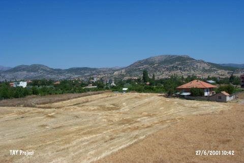
| Location: This site is located in Kahveler Mevkii of Mimar Sinan quarter of Bucak District; 250-300 m east of Burdur-Antalya highway; southeast of Burdur Province. |
| Geography and Environment: Höyücek is a small and low lying mound which rises 3.5 m above the level of the plain and has a 12 m diameter [Duru 1991a:87; 1992b:552]. |
| Destruction Details: The mound has been damaged due to agricultural activities and contemporary settlement. Its leveled parts are planted. There is a house on northern part and it is bordered by wired fence [TAYEx 27.6.2001]. |