| ©The Archaeological Settlements of Turkey - TAY Project | ||||||
|
|
||||||
Karagündüz |
||||||
|
|
||||||
| Ages | Maps | Photos | ||||
| EBA IA |
 |
 |
||||
|
|
||||||
|
Type:
|
Mound | |||||
|
Altitude:
|
1800 m | |||||
|
Diameter:
|
136 m- Direction: NE-SE | |||||
|
|
||||||
|
Region:
|
Eastern Anatolia | |||||
|
Province:
|
Van | |||||
|
District:
|
Merkez | |||||
|
Village:
|
Karagündüz | |||||
|
|
||||||
|
Destruction :
|
Illicit Digging - Contemporary Settlements | |||||
|
|
||||||
|
TAYEx:
|
Visited - 4/7/2003 | |||||
|
|
||||||
|
Registration State:
|
Registered For detailed registration information please refer to Turkish pages. | |||||
 |
||||||
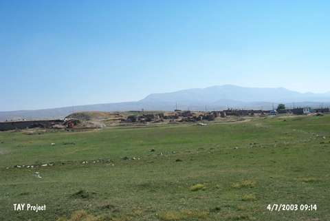
| Location: It lies where the Eski Karagündüz (Sarokonis) Village is located; 6 km north of the Erçek Sub-District; 34 km northeast of Van Province. Van-Özalp motorway passes from 4.8 km southeast of the mound. New village is being established 2 km northeast of the mound due to the increase in the water level. |
| Geography and Environment: It is located on the western end of the Erçek Düzü formed by the Memedik Stream spilling to the lake on the east- northeast of the Erçek Village. It is reported that the trade road running from Özalp and reaching out to Van passed through this lowland and the mound is the highest mound of the Van region. It is claimed that the mound which measures 8-9 m in height and ca. 75x50 m in dimensions has a 6-7 m thick cultural deposit belonging to EBA. There is a carved marble stone with the dimensions of 145x107x53 cm on the mound. |
| Destruction Details: Traces of illicit diggings were observed. On the slopes of the mound are the remains of the old village houses [TAYEx 4.7.2003]. |