| ©The Archaeological Settlements of Turkey - TAY Project | ||||||
|
|
||||||
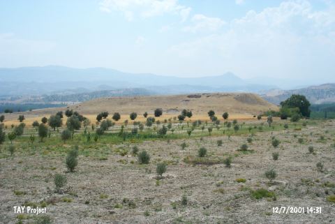
Kilise Tepe / Maltepe |
||||||
|
|
||||||
| Ages | Maps | Photos | ||||
| Neolithic Chalcolithic EBA IA |
 |
 |
||||
|
|
||||||
|
Type:
|
Mound | |||||
|
Altitude:
|
300 m | |||||
|
Diameter:
|
m- Direction: | |||||
|
|
||||||
|
Region:
|
Mediterranean | |||||
|
Province:
|
Mersin | |||||
|
District:
|
Mut | |||||
|
Village:
|
Kislaköy | |||||
|
|
||||||
|
|
||||||
|
|
||||||
|
TAYEx:
|
Visited - 12/7/2001 | |||||
|
|
||||||
|
Registration State:
|
For detailed registration information please refer to Turkish pages. | |||||
 |
||||||
| Location: It lies 1 km south of the Kisla Village; about 36 km northwest of Silifke District; some 20.5 km southeast of Mut District; southwest of the Mersin Province. To the north runs the Silifke-Mut motorway. It is easy to access. |
| Geography and Environment: The mound which will be submerged together with Çingene Tepe nearby under the reservoir waters of the Kayraktepe Dam built 10 km away from Silifke on the Göksu River is also known as Maltepe (Mut). There is another settlement called Maltepe located south of Çingene Tepe on the opposite western bank of the river. It is locally known as Kilise Tepe and it was illustrated under this name in a 1:25.000 maps. It stands on a conglomeratic elevation with steep slopes and flat uphill overlooking the valley formed by the Göksu River. On the northern foot of this rocky block; there is a fresh water spring. Settlement is suggested to house a cultural deposit of ca. 20 m thick. A stream called Kurtsuyu passing by the western side joins the Göksu River down in the valley. |
| Destruction Details: |