| ©The Archaeological Settlements of Turkey - TAY Project | ||||||
|
|
||||||
Seyitömer Höyük |
||||||
|
|
||||||
| Ages | Maps | Photos | ||||
| EBA IA |
 |
 |
||||
|
|
||||||
|
Type:
|
Mound | |||||
|
Altitude:
|
1180 m | |||||
|
Diameter:
|
m- Direction: | |||||
|
|
||||||
|
Region:
|
Aegean | |||||
|
Province:
|
Kütahya | |||||
|
District:
|
Merkez | |||||
|
Village:
|
Seyitömer | |||||
|
|
||||||
|
Destruction :
|
Illicit Digging | |||||
|
|
||||||
|
TAYEx:
|
Visited - 3/7/2004 | |||||
|
|
||||||
|
Registration State:
|
Registered For detailed registration information please refer to Turkish pages. | |||||
 |
||||||
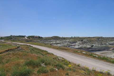
| Location: It is located within the territory of the Seyitömer Lignite Facilities; north of Seyitömer/Seydiömer Village; 24-25 km northwest of Kütahya Province as the crow flies. To the north of the mound are the lignite beds; to its east the factory and the Kütahya road. |
| Geography and Environment: The northern part of the mound is steep while the southern part is 20 m high and flat. The top hill is reported to measure ca. 200 square meters as a flat area [Aydin 1991:192]. The mound stands on a rocky clay strata called blue-green colored marn. Below this stratum lies a layer of lignite coal. The lignite opencast mine area, also including the mound is a pliocene aged lake formation. It consists of sedimentary rocks, conglomerates, clay layer in green and blue colors and a main coal seam. The composition of the coal seam ceiling is marl. The basin area was often subject to big scale tectonic movements. The topographic characteristics were almost lost due to constant removal of coal. The mound has an oval shape with an approximate height of 20 m. |
| Destruction Details: Pits which might be belonging to illicit diggings were observed next to the trenches on the eastern slope. The northern skirt of the mound was cut by the road [TAYEx 3.7.2004]. |