| ©The Archaeological Settlements of Turkey - TAY Project | ||||||
|
|
||||||
Sos Höyük |
||||||
|
|
||||||
| Ages | Maps | Photos | ||||
| EBA IA 14C |
 |
 |
||||
|
|
||||||
|
Type:
|
Mound | |||||
|
Altitude:
|
1760 m | |||||
|
Diameter:
|
m- Direction: | |||||
|
|
||||||
|
Region:
|
Eastern Anatolia | |||||
|
Province:
|
Erzurum | |||||
|
District:
|
Pasinler | |||||
|
Village:
|
Yigittasi | |||||
|
|
||||||
|
Destruction :
|
Contemporary Settlements - Attention | |||||
|
|
||||||
|
TAYEx:
|
Visited - 28/6/2003 | |||||
|
|
||||||
|
Registration State:
|
Registered For detailed registration information please refer to Turkish pages. | |||||
 |
||||||
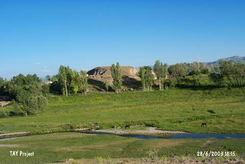
| Location: It lies 13 km west of the Pasinler District; 24 km northeast of the Erzurum Province. It is located where the Sos Village is situated; immediate (500 m) north of the road connecting the district to the province. The village is easily accessible through a stabilized road. The recent name of the village is Yigittasi. |
| Geography and Environment: The mound is obscured by the village of Yigittasi (Sosköy) in the Pasinler Plain irrigated by the Aras River. One of the branches of this river; Çökender; passes by the mound on the north [Sagona et al. 1995:fig.3]. The oval shaped mound in the center of the settlement measures ca. 1.2 ha. It reaches out to 150x270 m in dimensions together with the terraces. It is ca. 20 m high together with the natural elevation it stands on. The exact size of the settlement can only be obtained by soundings. It is obscured by the modern village; except the northern part of the central mound. The northern slope extends to the stream with a soft inclination while the other slopes have been damaged due to the removal of the soil and erosion. To the west; there is a section which is 8 m high. |
| Destruction Details: The mound is occupied by contemporary settlements from its skirts to the slopes [TAYEx 28.6.2003]. |