| ©The Archaeological Settlements of Turkey - TAY Project | ||||||
|
|
||||||
Samsin |
||||||
|
|
||||||
| Ages | Maps | Photos | ||||
| Neolithic Chalcolithic |
 |
 |
||||
|
|
||||||
|
Type:
|
Mound | |||||
|
Altitude:
|
70 m | |||||
|
Diameter:
|
m- Direction: | |||||
|
|
||||||
|
Region:
|
Mediterranean | |||||
|
Province:
|
Osmaniye | |||||
|
District:
|
Kadirli | |||||
|
Village:
|
Koçyurdu | |||||
|
|
||||||
|
Destruction :
|
Agriculture | |||||
|
|
||||||
|
TAYEx:
|
Visited - 31/7/2001 | |||||
|
|
||||||
|
Registration State:
|
For detailed registration information please refer to Turkish pages. | |||||
 |
||||||
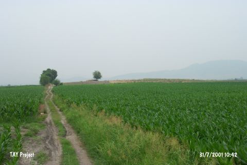
| Location: This site lies northeast of the city of Adana; 15 km south of the town of Kadirli; 4 km east of the Ceyhan-Kadirli highway; along the dirt road that goes to the villages of Koçyurdu (Endel) and Eskiler. |
| Geography and Environment: The mound lies along a road; on the flanks of the Anti-Taurus Mountains. It is an oval-shaped mound which is 50x70 m in diameter and 7 m high. |
| Destruction Details: The mound has been fairly damaged due to plowing. On the top of it is a cement pool measuring 3x3 m. The northern section has also been damaged by an irrigation channel [TAYEx 31.7.2001]. |