| ©The Archaeological Settlements of Turkey - TAY Project | ||||||
|
|
||||||
Bozüyük |
||||||
|
|
||||||
| Ages | Maps | Photos | ||||
| EBA |
 |
 |
||||
|
|
||||||
|
Type:
|
Mound | |||||
|
Altitude:
|
720 m | |||||
|
Diameter:
|
m- Direction: | |||||
|
|
||||||
|
Region:
|
Marmara | |||||
|
Province:
|
Bilecik | |||||
|
District:
|
Bozüyük | |||||
|
Village:
|
Merkez | |||||
|
|
||||||
|
Destruction :
|
Contemporary Settlements - Attention | |||||
|
|
||||||
|
TAYEx:
|
Visited - 12/7/2000 | |||||
|
|
||||||
|
Registration State:
|
For detailed registration information please refer to Turkish pages. | |||||
 |
||||||
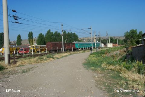
| Location: It is reported to locate next to a modern mosque; south of the train station; near Bozüyük District of Bilecik Province. The site was found by T. Efe by the help of the photographs taken during the excavation. The mound has been almost demolished at present. It is stated that during the construction of the mosque many sherds were found in the foundation pits. |
| Geography and Environment: The size of the mound is estimated to measure 13 m high; 50 m wide. It is estimated on the basis of a comparison of the human sizes to the background. It is a small settlement. |
| Destruction Details: The mound has completely vanished. Istanbul-Ankara railroad passes over the exact location of the settlement [TAYEx 12.7.2000]. |