| ©The Archaeological Settlements of Turkey - TAY Project | ||||||
|
|
||||||
Girikihaciyan |
||||||
|
|
||||||
| Ages | Maps | Photos | ||||
| Chalcolithic 14C |
 |
 |
||||
|
|
||||||
|
Type:
|
Mound | |||||
|
Altitude:
|
750 m | |||||
|
Diameter:
|
m- Direction: | |||||
|
|
||||||
|
Region:
|
Southeastern Anatolia | |||||
|
Province:
|
Diyarbakir | |||||
|
District:
|
Ergani | |||||
|
Village:
|
Ekinciler | |||||
|
|
||||||
|
Destruction :
|
Agriculture | |||||
|
|
||||||
|
TAYEx:
|
Visited - 7/9/2001 | |||||
|
|
||||||
|
Registration State:
|
Registered For detailed registration information please refer to Turkish pages. | |||||
 |
||||||
| Location: The site lies in Diyarbakir; approximately 20 km southeast of Ergani District; approximately 1 km east of Ekinciler Village (Asagi Ekinciyan); northeast of Ergani-Diyarbakir road. Ergani-Diyarbakir railway passes southwest of the mound. It is also known as Gerikihaciyan or Girikhaciyan. The location code of the site is R 56 / 25. |
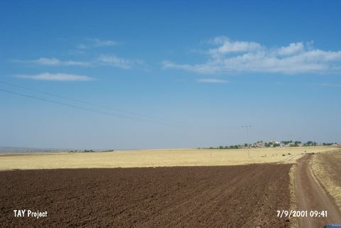
| Geography and Environment: The 3 m high mound is located northeast of the broad Diyarbakir Plain; which is irrigated by Bogazçay and extends from Ergani to Diyarbakir with a pass to the North Syria Valley at the south. The mound; 175 m in diameter (250 m maximum); is used for agriculture in the present; and there are small fresh water springs around it. There are low hills covered with oaks at the northeast; and bushes at the west [Watson-Le Blanc 1990:5]. |
| Destruction Details: The mound is being used for agricultural activities and it is completely sown [TAYEx 7.9.2001]. |